Southampton town walls

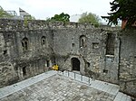
Southampton's town walls are a sequence of defensive structures built around the town in southern England. Although earlier Roman and Anglo-Saxon settlements around Southampton had been fortified with walls or ditches, the later walls originate with the move of the town to the current site in the 10th century. This new town was defended by banks, ditches and the natural curve of the river and coastline. The Normans built a castle in Southampton but made no attempts to improve the wider defences of the town until the early 13th century, when Southampton's growing prosperity as a trading centre and conflict with France encouraged the construction of a number of gatehouses and stone walls to the north and east sides of the settlement. In 1338 Southampton was raided by French forces; the town's defences proved inadequate, particularly along the quays on the west and south of the city. Edward III ordered some immediate improvements to Southampton's town walls but it was not until the 1360s that substantial work began. Over the coming decades the town was entirely enclosed by a 2 km (1.25-mile) long stone wall, with 29 towers and eight gates. With the advent of gunpowder weapons in the 1360s and 1370s, Southampton was one of the first towns in England to install the new technology to existing fortifications and to build new towers specifically to house cannon. Southampton's town walls remained an important defensive feature during the 15th century, the gatehouses sometimes being used as important civic facilities, including acting as the town's guildhall and housing the town's gaol. From the end of the 17th century their importance steadily declined and the walls were slowly demolished or adapted for other uses throughout the 18th and 19th centuries. This process continued into the early 20th century until, in the post-war years, the walls were recognised as an important historical feature of Southampton. Conservation projects have since occurred and the walls are now promoted as a tourist attraction.
Excerpt from the Wikipedia article Southampton town walls (License: CC BY-SA 3.0, Authors, Images).Southampton town walls
Castle Way, Southampton St Mary's
Geographical coordinates (GPS) Address Nearby Places Show on map
Geographical coordinates (GPS)
| Latitude | Longitude |
|---|---|
| N 50.9007 ° | E -1.4054 ° |
Address
Castle House
Castle Way
SO14 2BP Southampton, St Mary's
England, United Kingdom
Open on Google Maps


