Hittin

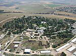
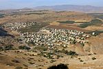
Hittin (Arabic: حطّين, transliterated Ḥiṭṭīn (Arabic: حِـطِّـيْـن) or Ḥaṭṭīn (Arabic: حَـطِّـيْـن)) was a Palestinian village located 8 kilometers (5 mi) west of Tiberias before it was occupied by Israel during the 1948 Arab-Israeli war when most of its original residents became refugees. As the site of the Battle of Hattin in 1187, in which Saladin reconquered most of Palestine from the Crusaders, it has become an Arab nationalist symbol. The shrine of Nabi Shu'ayb, venerated by the Druze and Sunni Muslims as the tomb of Jethro, is on the village land. The village was ruled by the Ottoman Empire from the 16th century until the end of World War I, when Palestine became part of the British Mandate for Palestine. On July 17 1948, the village was occupied by Israel, after its residents fled out of their homes because of Nazareth's occupation. in later years, the Moshavs Arbel and Kfar Zeitim were erected where Hittin used to be.
Excerpt from the Wikipedia article Hittin (License: CC BY-SA 3.0, Authors, Images).Hittin
Galil Tachton Regional Council
Geographical coordinates (GPS) Address Nearby Places Show on map
Geographical coordinates (GPS)
| Latitude | Longitude |
|---|---|
| N 32.806944444444 ° | E 35.453333333333 ° |
Address
Galil Tachton Regional Council
North District, Israel
Open on Google Maps


