place

Beechwood Park (mansion)

Country houses in HertfordshireFlamsteadGrade I listed buildings in HertfordshireUse British English from August 2018
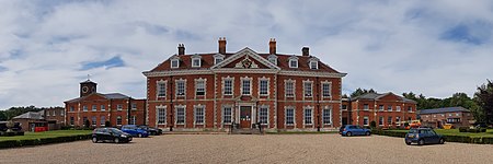
Beechwood Park 2020 07 23

Beechwood Park was a mansion, near Markyate, Hertfordshire, England. It now houses Beechwood Park School.

Excerpt from the Wikipedia article Beechwood Park (mansion) (License: CC BY-SA 3.0, Authors, Images).

Beechwood Park (mansion)
Beechwood Lane, St Albans Flamstead

Geographical coordinates (GPS) Address Phone number Nearby Places
placeShow on map

Wikipedia: Beechwood Park (mansion)Continue reading on Wikipedia

Geographical coordinates (GPS)

Latitude Longitude
N 51.81917 ° E -0.48477 °
placeShow on map

Address

Beechwood Park School

Beechwood Lane
AL3 8AW St Albans, Flamstead
England, United Kingdom
mapOpen on Google Maps

Phone number

call+441582840333

Beechwood Park 2020 07 23
Share experience

Nearby Places

Markyate Rural District

Markyate Rural District was a short-lived rural district in Hertfordshire, England from 1894 to 1897, on the borders with Bedfordshire. The district was created under the Local Government Act 1894 from the parts of the Luton Rural Sanitary District which were within Hertfordshire. The rest of the Luton Rural Sanitary District became the Luton Rural District. Prior to the 1894 Act the parishes of Caddington and Studham had both straddled the county boundary, and they were each split into separate parishes for the parts in each county, with the Caddington (Hertfordshire) and Studham (Hertfordshire) parishes being included in the Markyate Rural District.The Markyate Rural District was not a single contiguous area, but two separate blocks of land. The western part comprised the parish of Studham (Hertfordshire) and a detached part of Whipsnade parish. The eastern part comprised the parishes of Caddington (Hertfordshire) and Kensworth. The population of these areas in 1891 had been 1,808. Although the district took its name from the village of Markyate, only the north-eastern part of the village was actually in the Markyate Rural District, with the southern part being in Flamstead parish in the Hemel Hempstead Rural District and the north-western part of Markyate being in the parishes of Humbershoe and Houghton Regis in the Luton Rural District. This gave rise to confusion, with one candidate's nomination at the election in December 1894 being invalid for assuming that Humbershoe was in the Markyate district, when it was in the Luton district.All the councillors on the Markyate Rural District Council were also guardians on the Luton Board of Guardians, and the Markyate Rural District Council was administered from the workhouse in Luton rather than any premises within the district itself. The first meeting of the Markyate Rural District Council was held on 7 January 1895 at the board room of the Luton Union Workhouse. Frederick William Partridge, a Liberal, was appointed the chairman of the council. He would serve as chairman for the whole of the council's existence.The Markyate Rural District was effectively created as a temporary measure to comply with the Local Government Act 1894 pending an anticipated rationalisation of boundaries in the area. Proposals had been put forward under the Local Government (Boundaries) Act 1887, but had not been implemented at the time. Discussions on what changes might be acceptable continued after the Markyate Rural District was created. An inquiry was held in February 1896 into a proposal to transfer most of the Markyate Rural District into the Luton Rural District in Bedfordshire, with the exception of the detached part of Whipsnade, which would be added to Flamstead, and the part of Caddington (Hertfordshire) that was within the ecclesiastical parish of St John Markyate, which would become part of a new civil parish of Markyate in the Hemel Hempstead Rural District in Hertfordshire. This was the same proposal as had been put forward under the 1887 act. There were objections from Kensworth, which wanted to stay in Hertfordshire, and from Hertfordshire County Council, which felt that it was losing too much rateable value in the proposed transfers. There was general agreement that the village of Markyate should be brought into a single parish, but disagreement as to whether that parish should be placed in Hertfordshire or Bedfordshire. Eventually the scheme as originally proposed was accepted, with the necessary order being presented to Parliament in May 1897. The changes took effect on 30 September 1897.
Studham
Studham

Studham is a village and civil parish in the county of Bedfordshire. It has a population of 1,182. The parish bounds to the south of the Buckinghamshire border, and to the east is the Hertfordshire border. The village lies in the wooded south facing dip slope of the Chiltern Hills. The hamlet of Holywell is located to the north of Studham, and forms part of the same civil parish. In the Domesday Book of 1086 it was recorded as Estodham. Studham's church celebrated its millennium in 1997. The ancient parish of Studham straddled the Bedfordshire/Hertfordshire border. It also had a detached part known as Humbershoe which lay to the east of the rest of the parish, which contained the north-western part of the village of Markyate. Humbershoe became a separate civil parish in 1866, and was separated from the ecclesiastical parish of Studham in October 1877 when it was included in the new ecclesiastical parish of St John Markyate Street. In December 1894, under the Local Government Act 1894, the parish of Studham was partitioned into two parts, one on each side of the county border. The Studham (Bedfordshire) parish was included in the Luton Rural District, whilst the Studham (Hertfordshire) parish was included in the Markyate Rural District. The two parishes were re-united as a single parish less than three years later, in September 1897, when the Studham (Hertfordshire) parish was transferred from Hertfordshire to Bedfordshire.The village currently has two pubs, the older of which, The Bell, is considered to have been in existence before the English Civil War. In the early 20th century, work to make safe the old well in the pub garden revealed discarded or hidden civil war weapons. In the early evening of 23 May 1948 an ex-RAF Handley Page Halifax, registered G-AIZO, and operated by Bond Air Services Ltd. carrying a cargo of apricots from Valencia, Spain, crashed at Studham.

Great Gaddesden
Great Gaddesden

Great Gaddesden is a village and civil parish in Dacorum Hundred in Hertfordshire, England. It is located in the Chiltern Hills, north of Hemel Hempstead. The parish borders Flamstead, Hemel Hempstead, Nettleden and Little Gaddesden and also Studham in Bedfordshire. The Church of St. John the Baptist was probably the site of a pre-Christian sanctuary. The church shows features of every period since the 12th century. Part of the chancel with Roman bricks dates back to the early 12th century. The old church was extended by the south aisle in the 13th century and the north aisle in the 14th century, while the west tower was built in the 15th century and the north chapel in the 18th. The medieval convent of St Margaret's stood northwest of the village. For a while the site served as a WW2 Royal Canadian Air Force transit camp and later a boarding school for children with special needs, and it is now a Theravadin Buddhist monastery of Thai Forest Tradition, the Amaravati Buddhist Monastery, complete with temple. Gaddesden Place, east of the village, was built from 1768 to 1773 for the Halsey family. It is surrounded by a large park. In 1905 a fire destroyed the interior of the main house. The River Gade takes its name from Gaddesden. Its clear water is used for watercress beds along the river, and at Water End, south of Great Gaddesden, is an old corn mill. The bridge over the river at Water End has a medieval appearance but was built in the 19th century.