place

Roman Bridge of Catribana
Ancient Roman building and structure stubsBuildings and structures in Lisbon DistrictPortuguese bridge (structure) stubsRoman bridges in Portugal
Catribana1
Catribana1

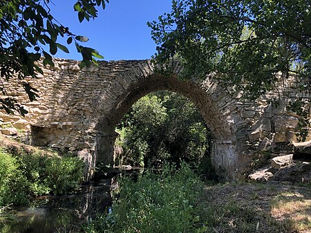
The Roman Bridge of Catribana is located near the village of Catribana in the parish of São João das Lampas, in the municipality of Sintra in the Lisbon District of Portugal. Not being identified as a Roman bridge until the 1980s, and having suffered considerable degradation, it was restored in 2019.The bridge, which crosses the Bolelas stream, is made of local limestone blocks. It is likely to have provided access for a Roman villa to a main road or connected two important Roman villas at the time when the area was part of the Roman Olisipo (roughly corresponding to the modern-day Lisbon Municipality), in the province of Lusitania, which formed part of the Roman Empire. It is composed of a single arch and parapet, and has undergone several changes over the centuries. On its south side is a section of a Roman path, about 50 meters long, which gives access to the bridge. Close to the bridge archaeologists have identified vestiges of a Roman-era cemetery together with remains of a Neolithic settlement.

Excerpt from the Wikipedia article Roman Bridge of Catribana (License: CC BY-SA 3.0, Authors, Images).

Roman Bridge of Catribana
Ponte romana da Catribana,

Geographical coordinates (GPS) Address External links Nearby Places
placeShow on map

Wikipedia: Roman Bridge of CatribanaContinue reading on Wikipedia

Geographical coordinates (GPS)

Latitude Longitude
N 38.888888888889 ° E -9.4136111111111 °
placeShow on map

Address

Ponte romana da Catribana (Caminho do Castelo)

Ponte romana da Catribana
2705-568 (São João das Lampas e Terrugem)
Portugal
mapOpen on Google Maps

linkWikiData (Q17389990)
linkOpenStreetMap (397520226)

Catribana1
Catribana1
Share experience

Nearby Places

Barreira Megalithic Complex

The Barreira Megalithic Complex (Portuguese: Conjunto Megalítico de Barreira) is located in the Sintra municipality in the Lisbon District of Portugal. Situated on a small wooded hill overlooking the village of Odrinhas, site of Roman ruins and an archaeological museum, it consists of about twenty menhirs and other monoliths or megaliths.The site, which is assumed to be a dolmen or cromlech, contains mainly cylindrical stones of varying heights, with the largest being approximately four metres tall. The size of the stones decreased as they became more distant from the central menhir and the megaliths were arranged irregularly depending on the terrain. No carved or painted symbols have been detected, except for a few pairs of small circular cavities, possibly representing eyes. A small number of items have been found to the west of the complex, including flints from the Lower Paleolithic, ceramic fragments and other items from the Neolithic period, and ceramic fragments from the Iron Age, suggesting that the site has been reused over time.The complex was not identified as a megalithic site until 1961 when it was studied by Gil Estevam Miguéis Andrade and Eduardo Prescott Vicente, who continued their studies in subsequent years. In 1975 several monoliths were removed to be used in construction work at the Port of Ericeira. In 1985, three more menhirs were also removed by the landowners, including the central monolith. It was classified as a Site of Public Interest in 1993.

Praia das Maçãs Prehistoric Monument

The Praia das Maçãs Prehistoric Monument, also known as the Tholos of Outeiro das Mós, consists of an artificial Neolithic cave and a Chalcolithic domed or beehive tomb. It is situated close to the Praia das Maçãs beach, near the town of Colares in Sintra municipality, in the Lisbon District of Portugal. The area was discovered in 1927. As an important prehistoric sepulchral site, it was classified as a national monument in 1974. Surrounded by housing, the location has been designated as a special zone of protection, and construction is forbidden. Plans by Sintra and the Directorate-General for Cultural Heritage to turn the complex into a museum area, first discussed in 2001, have not yet been implemented. For purposes of protection the site has been covered by sand and there is little presently visible. The artificial cave was probably dug into the rock in the second half of the 4th millennium BC or early in the 3rd. The tholos was added later. The site is seen as a good example of the practice of re-appropriation of symbolic locations, resulting in funeral practices of two different eras coexisting in the same space. After discovery of the site by an agricultural worker in 1927 there were limited excavations by the National Museum of Archaeology and Ethnology but little work on the necropolis was really carried out until archaeologists Vera Leisner, Georges Zbyszewski and Octávio da Veiga Ferreira excavated it, starting in 1969, after having seen items discovered unofficially by a private collector in the 1930s. Further work by Sintra Council was carried out in 1981. The Neolithic cave has a diameter of around 2 m (6 ft 7 in) and was originally covered with stone supports. The later tholos was composed of a circular chamber with a diameter of approximately 5.5 m (18 ft). Walls were constructed with limestone slabs placed horizontally. A pillar was raised in the centre to support a dome. An access corridor, about 3.5 m (11 ft) long, connected the chamber to a 2-metre-wide atrium. Items found at the site have included geometric microliths, arrowheads, polished axes, and cylindrical idols. These have been preserved at the National Museum of Archaeology and Ethnology in Lisbon, and the Regional Museum of Sintra.