place

Chaudière Bridge

1828 establishments in Lower Canada1828 establishments in Upper Canada1844 establishments in Canada1892 establishments in Ontario1892 establishments in Quebec
1919 establishments in Ontario1919 establishments in QuebecBridges completed in 1828Bridges completed in 1844Bridges completed in 1892Bridges completed in 1919Bridges in GatineauBridges in OttawaBridges over the Ottawa RiverRoad bridges in OntarioRoad bridges in QuebecTruss bridges in Canada
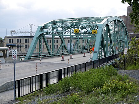
Chaudiere Bridge 2013

The Chaudière Bridge (French: Pont de la Chaudière) crosses the Ottawa River about 1 km (0.6 mi) west of Parliament Hill, joining the communities of Gatineau, Quebec and Ottawa, Ontario, linking Rue Eddy in the Hull sector of Gatineau and Booth Street in Ottawa. The bridge is one portion of multiple spans constituting the Chaudière Crossing, which still contain portions of the first bridge linking Ottawa with Hull dating back to the time of Colonel By in the 1820s. The bridge passes through the E.B. Eddy Company complex adjacent to the Chaudière Falls, from which the bridge gets its name.

Excerpt from the Wikipedia article Chaudière Bridge (License: CC BY-SA 3.0, Authors, Images).

Chaudière Bridge
Chaudière Bridge, (Old) Ottawa Hull

Geographical coordinates (GPS) Address Nearby Places
placeShow on map

Wikipedia: Chaudière BridgeContinue reading on Wikipedia

Geographical coordinates (GPS)

Latitude Longitude
N 45.4211 ° E -75.7186 °
placeShow on map

Address

Pont de la Chaudière

Chaudière Bridge
K1A 0N9 (Old) Ottawa, Hull
Quebec, Canada
mapOpen on Google Maps

Chaudiere Bridge 2013
Share experience

Nearby Places

Chaudière Falls
Chaudière Falls

The Chaudière Falls, also known as the Kana:tso or Akikodjiwan Falls, are a set of cascades and waterfall in the centre of the Ottawa-Gatineau metropolitan area in Canada where the Ottawa River narrows between a rocky escarpment on both sides of the river. The location is just west of the Chaudière Bridge and Booth-Eddy streets corridor, northwest of the Canadian War Museum at LeBreton Flats and adjacent to the historic industrial E. B. Eddy complex. The islands surrounding the Chaudière Falls, counter-clockwise, are Chaudière Island (immediately to the South & East of the falls), Albert Island (to the South), little Coffin Island was just south of Albert Island but is now submerged, Victoria Island and Amelia Island, (which was separated from Victoria Island in 1836 by Government timber slide; now fused to Victoria Island), Philemon Island (to the North) was originally called the Peninsular Village by the Wrights but became an island when the timber slide was built in 1829 (some maps identify it as Wright Island, but that is incorrect) it is now fused to south shore of City of Gatineau, and Russell Island, now submerged, was at the head of the Falls before the Ring dam was built. The falls are about 60 metres (200 ft) wide and drop 15 metres (49 ft). The area around the falls was once heavily industrialized, especially in the 19th century, driving growth of the surrounding cities.The damming of the river and the presence of industry have greatly altered the lands surrounding the waterfall, and the fall's appearance. This is especially true in the summer when the Ottawa River is low, and the falls all but disappear because the water is diverted to power stations owned and operated by Portage Power, an affiliate of Hydro Ottawa. Inaccessible for generations, the Falls and hydro facilities are now publicly accessible since the opening of Chaudiere Falls park in 2017, designed by architect Douglas Cardinal. Other properties adjacent to the Falls are slated for development by public and private interests, including an Indigenous welcome centre on Victoria Island, led by the National Capital Commission (NCC) with regional First Nation representatives, and Zibi, a private mixed-use redevelopment project.

Canadian War Museum
Canadian War Museum

The Canadian War Museum (French: Musée canadien de la guerre; CWM) is a national museum on the country's military history in Ottawa, Ontario, Canada. The museum serves as both an educational facility on Canadian military history, in addition to serving as a place of remembrance. The 440,000 square metres (4,700,000 sq ft) museum building is situated south of the Ottawa River in LeBreton Flats. The museum houses a number of exhibitions and memorials, in addition to a cafeteria, theatre, curatorial and conservation spaces, as well as storage space. The building also houses the Military History Research Centre, the museum's library and archives. The Canadian War Museum was formally established in 1942, although portions of the museum's collections originate from a military museum that operated from 1880 to 1896. The museum was operated by the Public Archives of Canada until 1967, when the National Museums of Canada Corporation was formed to manage several national institutions, including the war museum. In the same year, the war museum was relocated from its original building to the former Public Archives of Canada building. Management of the museum was later assumed by the Canadian Museum of Civilization Corporation (later renamed the Canadian Museum of History Corporation) in 1990. Plans to expand the museum during the mid-1990s resulted in the construction of a new building at LeBreton Flats. Designed by Moriyama & Teshima Architects and Griffiths Rankin Cook Architects, the new Canadian War Museum building was opened to the public in 2005. The museum's collection contains over 500,000 pieces of materials related to military history, including over 13,000 pieces of military art. In addition to its permanent exhibition, the museum has hosted and organized a number of travelling exhibitions relating to Canadian military history.

National Holocaust Monument

The National Holocaust Monument (French: Monument national de l'Holocauste) is a Holocaust memorial in Ottawa, Ontario, across from the Canadian War Museum at the northeast corner of Wellington and Booth Streets, and about 1.5 km away from Parliament Hill. The memorial has been designed by Daniel Libeskind.The National Holocaust Monument Act (Bill C-442), which established plans to create the memorial in Canada's capital, received Royal Assent on March 25, 2011. The law was introduced as a private members bill by Tim Uppal, Minister of State and MP for Edmonton—Sherwood Park and received unanimous support.The monument features a view of the Peace Tower and photographs by Edward Burtynsky. The team was led by Lord Cultural Resources.The monument is overseen by the National Capital Commission. The monument was planned to be unveiled in the fall of 2015, but later pushed back to the spring of 2017 due to delays in construction. The official unveiling occurred on September 27, 2017. In 2017, when the National Holocaust Monument of Canada was unveiled in Ottawa, the opening plaque made no mention of the six million Jews killed by the Nazis. Subsequently, chair Rabbi Daniel Friedman took responsibility for the error.The monument was built due to the persistent activism of former University of Ottawa student, Laura Grosman. Laura began advocating for a monument to be built commemorating the Nazis atrocities and as a beacon of light for Canadian Holocaust survivors. She campaigned and met with various Members of Parliament to support the introduction of a Private Members Bill. She is the granddaughter of a Polish-born Holocaust survivor.