Thornton and Allerton

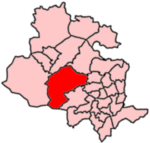
Thornton and Allerton (population 18,000 - 2021 ward profile) is a ward within the City of Bradford Metropolitan District Council in the county of West Yorkshire, England, named after the villages of Thornton and Allerton around which it is drawn. The population has increased considerably over the past 20 years, with an increase of nearly a fifth (3,000) from the 2001 UK census. The ward has also urbanised considerably, particularly in Allerton, which has contributed to a notable swing from Conservative to Labour in the last decade, and can be described as primarily suburban. As well as the villages of Thornton and Allerton, the ward includes the smaller village of Sandy Lane, hamlets of Keelham and Little Egypt, and neighbourhoods of Stony Lane, Broom Hill, School Green and Leaventhorpe.
Excerpt from the Wikipedia article Thornton and Allerton (License: CC BY-SA 3.0, Authors, Images).Thornton and Allerton
Bradford Allerton
Geographical coordinates (GPS) Address Nearby Places Show on map
Geographical coordinates (GPS)
| Latitude | Longitude |
|---|---|
| N 53.802 ° | E -1.834 ° |
Address
BD15 8HJ Bradford, Allerton
England, United Kingdom
Open on Google Maps


