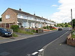
Lower Broadheath

Lower Broadheath is a village and civil parish in the Malvern Hills district of Worcestershire, England. According to the 2011 census it had a population of 1,728. The parish also includes Upper Broadheath. The village is about 3 miles north-west of Worcester. There are many housing estates in the village, including the Jacomb estate (Jacomb Road, Jacomb Drive, Jacomb Close and Rectory Close). The village has a village hall, church, post office and shop, a village green (containing a football pitch, running track and many children's play areas) and a large village common. There is also a primary school (Broadheath C.E. Primary School). The school contains around 150 children, from the age of four up to eleven. There are also two pubs in the village.
Excerpt from the Wikipedia article Lower Broadheath (License: CC BY-SA 3.0, Authors, Images).Lower Broadheath
B4204, Malvern Hills District Broadheath
Geographical coordinates (GPS) Address Nearby Places Show on map
Geographical coordinates (GPS)
| Latitude | Longitude |
|---|---|
| N 52.209171 ° | E -2.273226 ° |
Address
The Bell Inn
B4204
WR2 6QG Malvern Hills District, Broadheath
England, United Kingdom
Open on Google Maps


