Salle, Norfolk

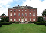
Salle ( SAWL) is a small village and civil parish in the Broadland district, in the county of Norfolk, England. 1.5 miles (2.4 km) to the south is the market town of Reepham. The name, pronounced Saul, derives from "Sallow Wood" — sallow referring to willow in Norfolk dialect. It is sometimes written, now archaically, Sall. The parish was renamed from "Sall" to "Salle" on 18 October 1994.The civil parish has an area of 8.21 square kilometres (3.17 sq mi) and in 2001 had a population of 50 in 21 households.Salle is celebrated for its fine, huge late medieval church, which retains the lower part of its rood screen. The Salle Park Estate owns much of the village and surrounding agricultural land.
Excerpt from the Wikipedia article Salle, Norfolk (License: CC BY-SA 3.0, Authors, Images).Salle, Norfolk
The Street, Broadland
Geographical coordinates (GPS) Address Nearby Places Show on map
Geographical coordinates (GPS)
| Latitude | Longitude |
|---|---|
| N 52.78 ° | E 1.126 ° |
Address
The Street
NR10 4SD Broadland
England, United Kingdom
Open on Google Maps


