place

Hout Bay

Suburbs of Cape TownUse South African English from May 2020
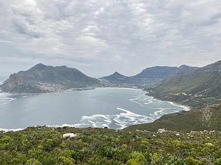
Chapman's Peak 2022 02

Hout Bay (Afrikaans: Houtbaai, meaning "Wood Bay") is a seaside suburb of Cape Town in the Western Cape province of South Africa. It is situated in a valley on the Atlantic seaboard of the Cape Peninsula, twenty kilometres south of the Central business district of Cape Town. The name "Hout Bay" can refer to the town, the bay on which it is situated, or the entire valley. The area was originally made up of two farms, which were slowly subdivided to make way for urban expansion. While still maintaining its rural atmosphere, the area of Hout Bay has more than 5,960 residences inhabited by a population of at least 17,900 people (as of 2011).

Excerpt from the Wikipedia article Hout Bay (License: CC BY-SA 3.0, Authors, Images).

Hout Bay
Daphne Street,

Geographical coordinates (GPS) Address Nearby Places
placeShow on map

Wikipedia: Hout BayContinue reading on Wikipedia

Geographical coordinates (GPS)

Latitude Longitude
N -34.033333333333 ° E 18.35 °
placeShow on map

Address

Daphne Street

Daphne Street
7872 , Cape Town Ward 74
Western Cape, South Africa
mapOpen on Google Maps

Chapman's Peak 2022 02
Share experience

Nearby Places

Table Mountain National Park Marine Protected Area

The Table Mountain National Park Marine Protected Area is an inshore marine protected area around the Cape Peninsula, in the vicinity of Cape Town, South Africa. It was proclaimed in Government Gazette No. 26431 of 4 June 2004 in terms of the Marine Living Resources Act, 18 of 1998.The MPA is of value for conservation of a wide range of endemic species, and has considerable economic value as a tourist destination. It encloses a large number of recreational dive sites visited by local residents and tourists from further afield. The shark and whale watching tourist industries are also represented, and there are several popular surf breaks. The MPA is mainly a controlled zone where extractive activities are allowed under permit, with six small no-take zones. The MPA is administrated by the Table Mountain National Park, a branch of SANParks. The marine ecology is unusually varied for an area of this size, as a result of the meeting of two major oceanic water masses near Cape Point, and the park extends into two coastal marine bioregions. The ecology of the west or "Atlantic Seaboard" side of the park is noticeably different in character and biodiversity to that of the east, or "False Bay" side. Both sides are classified as temperate waters, but there is a significant difference in average temperature, with the Atlantic side being noticeably colder on average.The MPA contains culturally significant fish traps, historical wrecks and traditional fishing communities, and is also important for commercial fisheries. Part of the West Coast rock lobster industry takes place within the MPA – as well as recreational and subsistence fishers, and an illegal poaching industry mostly targeting abalone, rock lobster and territorial linefish from the no-take zones.