Reading built-up area

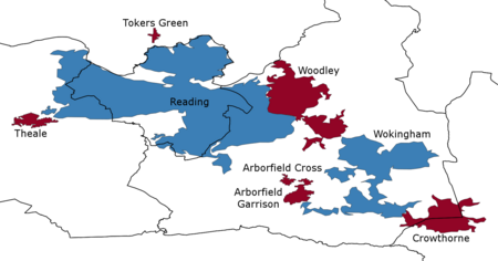
The Reading Built-up Area or Reading/Wokingham Urban Area is a name given by the Office for National Statistics to a conurbation in Berkshire, England, with a population of 318,014. This was a significant decrease from the population according to the 2001 census of 369,804 due to Bracknell no longer being considered part of the built-up area, but forming part of the Greater London Urban Area instead. Its largest population centre is Reading, and it also includes Arborfield, Woodley, Theale, Crowthorne, Earley and Wokingham. Part of the urban area, Crowthorne, is just to the north of Sandhurst, part of the Farnborough/Aldershot Urban Area, and its eastern extremity is just west of Bracknell part of the Greater London Urban Area.
Excerpt from the Wikipedia article Reading built-up area (License: CC BY-SA 3.0, Authors, Images).Reading built-up area
Coppice Road,
Geographical coordinates (GPS) Address Nearby Places Show on map
Geographical coordinates (GPS)
| Latitude | Longitude |
|---|---|
| N 51.44 ° | E -0.9 ° |
Address
Coppice Road 11
RG5 3QX
England, United Kingdom
Open on Google Maps


