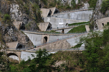
San Boldo Pass

The San Boldo Pass (in Italian Passo San Boldo, formerly Passo Sant'Ubaldo and Umbaldopass) is a small mountain pass in Veneto between the towns of Trichiana [329 m (1,079 ft)] and Tovena in the Cison di Valmarino region [272 m (892 ft)] over a distance of 17 km (11 mi). The pass lies at the southern edge of the Alps and connects the Val Belluna with the Val Mareno over a height of 706 m (2,316 ft). The mountain pass is called the SP 635 and only one lane is passable, the traffic is regulated by several sets of lights. There is a speed limit of 30 km/h (19 mph) and a height limit of 3.2 m (10.5 ft), after buses were repeatedly stuck in the tunnel. There are five tunnels blasted into the rock with hairpin turns or loops, and six bridges.
Excerpt from the Wikipedia article San Boldo Pass (License: CC BY-SA 3.0, Authors, Images).San Boldo Pass
Via San Boldo,
Geographical coordinates (GPS) Address Show on map
Geographical coordinates (GPS)
| Latitude | Longitude |
|---|---|
| N 46.005 ° | E 12.169722222222 ° |
Address
Via San Boldo
Via San Boldo
Veneto, Italy
Open on Google Maps