Beitar Illit
1984 establishments in the Palestinian territoriesCities in the West BankGush Etzion Regional CouncilPopulated places established in 1985Religious Israeli settlements ... and 1 more
Wikipedia extended-confirmed-protected pages

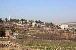
Beitar Illit (Hebrew: בֵּיתָר עִלִּית; officially Betar Illit; Arabic: بيتار عيليت) is a Haredi Jewish-Israeli settlement organized as a city council in the Gush Etzion settlement bloc, 10 kilometres (6.2 mi) southwest of Jerusalem in the West Bank. Beitar Illit is one of Israel's largest and most rapidly growing settlements, and in 2021 had a population of 63,220. The international community considers Israeli settlements in the West Bank illegal under international law, but the Israeli government disputes this.
Excerpt from the Wikipedia article Beitar Illit (License: CC BY-SA 3.0, Authors, Images).Beitar Illit
Beitar Ilit
Geographical coordinates (GPS) Address Nearby Places Show on map
Geographical coordinates (GPS)
| Latitude | Longitude |
|---|---|
| N 31.697777777778 ° | E 35.115555555556 ° |
Address
Beitar Ilit
Judea and Samaria, Palestinian Territories
Open on Google Maps


