place

Market Bosworth Rural District

Districts of England abolished by the Local Government Act 1972Districts of England created by the Local Government Act 1894History of LeicestershireLeicestershire geography stubsLocal government in Leicestershire
Rural districts of EnglandUse British English from August 2012

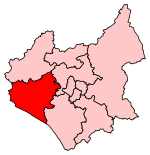
The rural district of Market Bosworth existed from 1894 to 1974 in Leicestershire, England. It was named after Market Bosworth, and was created under the Local Government Act 1894, based on the Market Bosworth rural sanitary district, and that part of the Atherstone rural sanitary district which was in Leicestershire. The parish of Higham on the Hill was added in 1936, from the Hinckley Rural District, which had been abolished under a County Review Order. In 1974 most of the district merged with Hinckley to form the new Hinckley and Bosworth district, apart from Ibstock, which went to North West Leicestershire.

Excerpt from the Wikipedia article Market Bosworth Rural District (License: CC BY-SA 3.0, Authors).

Market Bosworth Rural District
Sutton Lane, Hinckley and Bosworth Market Bosworth

Geographical coordinates (GPS) Address Nearby Places
placeShow on map

Wikipedia: Market Bosworth Rural DistrictContinue reading on Wikipedia

Geographical coordinates (GPS)

Latitude Longitude
N 52.62 ° E -1.4 °
placeShow on map

Address

Sutton Lane

Sutton Lane
CV13 0LB Hinckley and Bosworth, Market Bosworth
England, United Kingdom
mapOpen on Google Maps

Share experience

Nearby Places

Dixie Grammar School

Dixie Grammar School is a private school in Market Bosworth, Leicestershire. The earliest records of the School's existence date from 1320, but the school was re-founded in 1601 under the will of an Elizabethan merchant and Lord Mayor of London, Sir Wolstan Dixie, by his great-nephew Sir Wolstan Dixie of Appleby Magna, who came to live in Market Bosworth in 1608.The most distinguished of the School's former pupils is Thomas Hooker, founder of Hartford, Connecticut, known as the Father of American Democracy. Samuel Johnson, moralist, poet and author of the famous dictionary, taught at the school in the mid-eighteenth century. The main building of today's school was built in 1828 and faces the market square of Market Bosworth. A distinguished headmaster of the school was the Rev. Arthur Benoni Evans from 1829 till his death in 1854. The school ceased to exist as a "grammar school" in 1969, with the establishment of Market Bosworth High School (11–13 years) and Bosworth Community College, Desford (14–18 years), as much larger comprehensive schools found favour. The Leicestershire Independent Educational Trust was formed in 1983, and four years later the school was re-opened as a selective, independent, day school for boys and girls of all backgrounds between the ages of 10 and 18. Three years later the Junior School opened, moving in 2001 to its present premises, Temple Hall in Wellsborough.The Dixie Grammar provides education for the following ages of children: The Pippins Nursery School (ages 3–4)– in Wellsborough The Dixie Grammar Junior School (ages 5–10) – in Wellsborough The Dixie Grammar School (ages 10–18) – in Market BosworthThe school has maintained the Independent Schools' Inspectorate top rating of 'Excellent' for Educational Quality unbroken since 2015. The Headmaster, Mr Richard Lynn, has been in post since 2014.

Market Bosworth railway station

Market Bosworth railway station is a former stop on the London and North Western Railway and the Midland Railway, who jointly operated the line between Moira West Junction and Nuneaton as the Ashby and Nuneaton Joint Railway. The station was designed by the Midland Railway company architect John Holloway Sanders.The station is to the west of the market town of Market Bosworth. Nowadays it is part of the heritage Battlefield Line Railway, some 3 miles (5 km) to the south of the railway's base at Shackerstone. Original station buildings survive on platform 1, used by the private Station Garage. The track in platform one is a siding, used for the storage of wagons and diesel shunters in various states of disrepair. Platform 2 is on the running line and is the only one in use. The signal box also survives, as do several semaphore signals, though this signalling is not in commission thus the station is an unsignalled halt. The waiting room was originally at Chester Road on the Birmingham Cross-City Line; when this line was electrified between 1991 and 1993, the building was dismantled and reconstructed at Market Bosworth. Volunteers have been slowly restoring the station. The station encountered severe vandalism at Easter 2008 with one building, the Permanent Way hut, completely destroyed by arson. Any windows that were originally intact in the signalbox were smashed. Nonetheless, the railway continues to restore the station. In May 2009, a passenger train hauled by LNER Thompson Class B1 No. 61306 halted at the station for the first time in at least ten years to allow passengers to see the progress at the station. On the weekend of 19–20 March 2011, completion of a foot crossing at the south end of the station enabled it to be opened to the public for the first time. There is a car park in the former goods yard but only very basic facilities for passengers. There is a long-term aspiration to restore the passing loop at the station to allow two train operation over the line.

Ambion Hill
Ambion Hill

Ambion Hill is a hill in west Leicestershire, England, south of the town of Market Bosworth and lying south of the Sutton Cheney to Shenton road and north of Dadlington and of Fenn Lanes Roman road. The Ashby Canal passes to the south of the hill. The hill is the site of the deserted medieval village of Anebein.Ambion Hill was long considered to be the site of the Battle of Bosworth Field and is where the Bosworth Battlefield Heritage Centre is situated. The chronicler Raphael Holinshed wrote in 1577 that Richard III "pitched his field on a hill called Anne Beame, refreshed his soldiers and took his rest". This was taken by the C18th antiquary William Hutton to mean that Ambion Hill was the site of the battle. Hutton's book The Battle of Bosworth Field, published in 1788, was very influential in causing the hill to be accepted as the site of the battle.Leicestershire County Council set up the battlefield visitor centre at what was Ambion Hill Farm, in 1974. The work of Leicester University historian Daniel Williams was used to interpret the battle. Numerous historians challenged the Ambion Hill location for the battle and this led to a large-scale project (from 2005 to 2009) by the Battlefields Trust, headed by Glenn Foard, to attempt to definitively find the true location of the battlefield. It is now accepted that the core of the battlefield lies either side of Fenn Lanes, about two miles south-west of the visitor centre and that Ambion Hill was Richard III's camp on the night before the battle. The battlefield heritage centre now has a viewing point with the Fenn Lane Farm site and other notable points marked. Ambion Hill remains within the revised registered battlefield.A cairn built in 1813 marks the well from which according to tradition Richard III is said to have drunk prior to the battle. The cortège carrying Richard III's remains visited the hill during the procession before their interment in Leicester Cathedral in 2015.