place

Barwick in Elmet and Scholes

Civil parishes in West YorkshireUse British English from March 2020West Yorkshire geography stubs
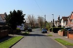
Highfield Lane, Barwick in Elmet. geograph.org.uk 231344

Barwick in Elmet and Scholes is a civil parish in the City of Leeds metropolitan borough in West Yorkshire, England. According to the 2001 census it had a population of 5,120, decreasing to 4,902 at the 2011 Census. The parish includes Barwick-in-Elmet and Scholes, situated in the north-eastern part of the borough. The parish council usually meets monthly.

Excerpt from the Wikipedia article Barwick in Elmet and Scholes (License: CC BY-SA 3.0, Authors, Images).

Barwick in Elmet and Scholes
Leeds Road, Leeds Barwick in Elmet and Scholes

Geographical coordinates (GPS) Address Nearby Places
placeShow on map

Wikipedia: Barwick in Elmet and ScholesContinue reading on Wikipedia

Geographical coordinates (GPS)

Latitude Longitude
N 53.8227 ° E -1.4126 °
placeShow on map

Address

Leeds Road

Leeds Road
LS15 4HS Leeds, Barwick in Elmet and Scholes
England, United Kingdom
mapOpen on Google Maps

Highfield Lane, Barwick in Elmet. geograph.org.uk 231344
Share experience

Nearby Places

Scholes railway station

Scholes railway station was a station in Scholes, Leeds, West Yorkshire, England, on the Cross Gates–Wetherby line. It opened on 1 May 1876 and closed on 6 January 1964. The former station building is now a restaurant, which from 1984 to 1999 used a Mk 1 railway carriage as extra rooms. The latter is now restored and in use on the Keighley and Worth Valley Railway.When opened, the station had a single platform and a brick station building on the up side of the line. The building was of a typical North Eastern Railway design and similar to those at Bardsey, Thorner, and Collingham Bridge as well as at Garforth station. A long siding was located opposite to the platform, but there was no passing loop. The small goods yard with two sidings was located north of the station. One siding with a loop served the coal drops, the other a cattle dock. There was no goods shed or crane, only a parcels shed on the platform.The local brickworks, established in 1877 by Isaac Chippindale sr. close to the station, were a main freight customer, but were not permitted their own sidings and had to transport their products to the station by road. Upon doubling of the line in 1901, a second platform with a wooden waiting room was built, and a third goods siding added. In the 1950s the road bridge across the tracks south of the station was reconstructed. While the station closed to passengers on 6 January 1964, it remained open for goods until 27 April 1964. The stationmaster ran a coal sale as a private concern under licence from the railways. Following closure, the business continued from the former goods yard, and moved later to Garforth. It closed upon retirement of the last stationmaster in 1993. The station building was leased to an electrical contractor in the late 1960s and converted into a restaurant in 1979.