place

Cora Bryant Wheeler House

1923 establishments in OregonA. E. Doyle buildingsArts and Crafts architecture in OregonHouses completed in 1923Houses on the National Register of Historic Places in Portland, Oregon
Oregon Registered Historic Place stubsPortland Historic LandmarksSouthwest Hills, Portland, Oregon
Wheeler CB House Portland Oregon

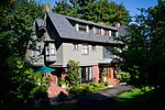
The Cora Bryant Wheeler House, also known as the Mrs. Coleman H. Wheeler House, is a historic house located in Portland, Oregon, United States. Architect A. E. Doyle designed this 1923 Arts and Crafts house to take full advantage of its prominent and demanding ridgetop location. The land was purchased by Coleman and Cora in 1918 from the Frank Dekum family. The house's complex lines and massing articulating the shape of the hill, and notably including a significant amount of lumber from the Wheelers' own timberlands in the Coast Range, the Wheeler House became an important later addition to the portfolio that made Doyle one of Portland's leading architects. Junior partner Pietro Belluschi and apprentice Richard Sundeleaf, each of whom later became a significant architect in his own right, provided on-site construction supervision. The house was added to the National Register of Historic Places in 1990.Cora died in 1951. Their daughter, Marguerite, still resided in the house, selling it in 1953.

Excerpt from the Wikipedia article Cora Bryant Wheeler House (License: CC BY-SA 3.0, Authors, Images).

Cora Bryant Wheeler House
Southwest Montgomery Drive, Portland Southwest Hills

Geographical coordinates (GPS) Address Nearby Places
placeShow on map

Wikipedia: Cora Bryant Wheeler HouseContinue reading on Wikipedia

Geographical coordinates (GPS)

Latitude Longitude
N 45.5146 ° E -122.697986 °
placeShow on map

Address

Southwest Montgomery Drive 1841
97201 Portland, Southwest Hills
Oregon, United States
mapOpen on Google Maps

Wheeler CB House Portland Oregon
Share experience

Nearby Places

Vista Ridge Tunnels
Vista Ridge Tunnels

The Vista Ridge Tunnels are highway tunnels through the Tualatin Mountains ("West Hills") of Portland, Oregon, United States. Located in the Goose Hollow neighborhood, the tunnels pass through a hillside locally known as Vista Ridge which is a half mile (1 km) west of downtown Portland. Sunset Highway, also known as U.S. Route 26, is carried through the tunnels, three lanes in each direction. They are Oregon's busiest tunnels. The eastbound tunnel is 1001 feet (305 m) in length; the westbound tunnel is 949 feet (289 m). Both have 41 ft (12.5 m) of horizontal and 15.58 ft (4.75 m) of vertical clearance. The eastbound tunnel was completed in 1969, the westbound a year later.There is a six-percent grade through the tunnels. Most of the tunnels' lengths are straight, though they curve southward at the west ends 35°.The tunnels were built with ventilation shafts which were never used. Instead, the shafts were later adapted for electrical wiring, so as to improve tunnel illumination without marring the tunnels' appearance with visible conduit.To improve tunnel safety for motorists, and decrease the tunnel lighting requirements, the original tunnel entrance faces were sandblasted to remove white paint and repainted a less luminescent tan color to reduce the range of visual light adaptation required by drivers. At one time there were computer-based electronic light controls, but they were replaced by relatively simple photo detectors and relays for durability and simplicity. The night lighting level is enabled permanently and is supplemented by two or three levels of daytime lighting.Except directly over the tunnels, the hillsides are steep and undeveloped forest, with some residential development along the top of the ridges. Landslides occasionally occur, but are usually minor and quickly cleared.The tunnels have been closed to hazardous material transport since November 1, 1994. As a result, US 26 is closed to hazardous material transport between I-405 and Oregon Route 217. The tunnels are located nearly at the bottom of a hill where the road gradient averages 6.5% over 2.25 mi (3.6 km). Close to the east portals is a 130-foot (40 m) tunnel underpass carrying SW 18th Avenue. Just outside the west portals is a 650-foot (200 m) tunnel under the lanes which carries eastbound Canyon Road from the exit ramp into Goose Hollow. The Robertson Tunnel for MAX Light Rail is underground approximately 800 feet (250 m) to the west. An electronic sign giving motorists real-time information on travel times to Highway 217 under current conditions, and other messages as needed, was installed above the east portal of the westbound tunnel in June 2017 and was activated in August 2018.The tunnel's internal lighting was upgraded to LED in July 2020. The replacement lights use about half the electricity of the previous high pressure sodium vapor bulbs and require replacement every 15-20 years instead of every two to four years. The LEDs have a color temperature of 4000 K.