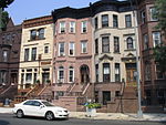
Bedford–Stuyvesant (), colloquially known as Bed–Stuy, is a neighborhood in the northern section of the New York City borough of Brooklyn. Bedford–Stuyvesant is bordered by Flushing Avenue to the north (bordering Williamsburg), Classon Avenue to the west (bordering Clinton Hill), Broadway to the east (bordering Bushwick and East New York), and Atlantic Avenue to the south (bordering Crown Heights and Brownsville). The main shopping street, Fulton Street runs east–west the length of the neighborhood and intersects high-traffic north–south streets including Bedford Avenue, Nostrand Avenue, and Stuyvesant Avenue. Bedford–Stuyvesant contains four smaller neighborhoods: Bedford, Stuyvesant Heights, Ocean Hill, and Weeksville (also part of Crown Heights). Part of Clinton Hill was once considered part of Bedford–Stuyvesant.
Bedford–Stuyvesant has the largest collection of intact and largely untouched Victorian architecture in the United States, with roughly 8,800 buildings built before 1900. Its building stock includes many historic brownstones. These homes were developed for the expanding upper-middle class from the 1890s to the late 1910s. These homes contain highly ornamental detailing throughout their interiors and have classical architectural elements, such as brackets, quoins, fluting, finials, and elaborate frieze and cornice banding.
Since the late 1930s, the neighborhood has been a major cultural center for Brooklyn's African American population. Following the construction of the Fulton Street subway line (A and C trains) in 1936, African Americans left an overcrowded Harlem for greater housing availability in Bedford–Stuyvesant. From Bedford–Stuyvesant, African Americans have since moved into the surrounding areas of Brooklyn, such as East New York, Crown Heights, Brownsville, and Fort Greene.
Bedford–Stuyvesant is mostly part of Brooklyn Community District 3, though a small part is also in Community District 8. Its primary ZIP Codes are 11205, 11206, 11216, 11221, 11233, and 11238. Bedford–Stuyvesant is patrolled by the 79th and 81st Precincts of the New York City Police Department. Politically it is represented by the New York City Council's 36th District.


