place

Clodock

Villages in Herefordshire
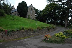
St. Clydawg's church, Clodock geograph.org.uk 2777132

Clodock Welsh: Clydog is a village in the west of Herefordshire, England. It lies on the River Monnow in the foothills of the Black Mountains, close to the border with Wales. The village is in the civil parish of Longtown. Before 1536 Clodock was in the marcher lordship of Ewyas Lacy. Until 1866 it was a large parish (until 1852 in the diocese of St David's), which included the chapelries of Craswall, Llanveynoe, Longtown and Newton. In 1866 each chapelry became a separate civil parish, and the village of Clodock became part of the civil parish of Longtown.The parish church is dedicated to St Clydog, king of Ewyas, who was killed during the 6th century. The present church dates from the 12th century, and is a Grade 1 Listed Building. It is completely un-Victorianised, with west gallery, box-pews, three-decker pulpit and seventeenth century sanctuary furniture.

Excerpt from the Wikipedia article Clodock (License: CC BY-SA 3.0, Authors, Images).

Geographical coordinates (GPS)

Latitude Longitude
N 51.941944444444 ° E -2.9822222222222 °
placeShow on map

Address


HR2 0PB , Crucorney
England, United Kingdom
mapOpen on Google Maps

St. Clydawg's church, Clodock geograph.org.uk 2777132
Share experience

Nearby Places

Walterstone
Walterstone

Walterstone (Welsh: Alt-yr-Ynys) is a village and civil parish in Herefordshire, England, near the Welsh border and the Brecon Beacons National Park, 14 miles (23 km) south-west of Hereford. The parish had a population of 97 in the 2001 UK Census and is grouped with Craswall, Llanveynoe and Longtown to form Longtown Group Parish Council for administrative purposes.There is a motte-and-bailey castle in the village to the west of St Mary's church and an Iron Age hill fort on high ground two-thirds of a mile (1.1 km) to the east. The River Monnow and the Welsh Marches railway line share a valley south-east of the village.Allt Yr Ynys, a Grade II listed 16th-century manor house 1+1⁄4 miles (2.0 km) south of the village, has been a country house hotel. The Grade II listed parish church of St Mary is part of the Ewyas Harold group of parishes. In the chancel, there is early 17th-century stained-glass depicting the quartered arms of the Cecils, brought from the nearby Allt Yr Ynys. The churchyard cross is listed Grade II*.The 300-year-old village pub, the Carpenter's Arms, is situated next to the church and has been in the same family for the last 100 years.In the 18th century, a Roman mosaic was reported to have been found in the parish. The exact site is not known but is thought to be in the Coed-y-Grafel area north of the village.In the 1870s the Imperial Gazetteer recorded the area of the village as 1,241 acres (502 ha) with a population of 173.

River Honddu (Monmouthshire)

The River Honddu (Welsh: Afon Honddu) (pronounced hon-thee) is a river in the Black Mountains within the Brecon Beacons National Park, southeast Wales. Early recorded versions of the name are of the form Hothenei and hodni which are believed to contain the adjective 'hawdd' meaning for example, pleasant or easy. Later forms such as Honddye have undergone metathesis whereby -ddn- became -ndd-.It rises within the county of Powys near the Gospel Pass at the head of the Vale of Ewyas down which it flows, passing southwards into Monmouthshire to Llanvihangel Crucorney before turning northeastwards to join the River Monnow at the point on the Wales-England border where that river too makes a sudden change of direction. The only significant tributary to join the Honddu is the Nant Bwch though numerous smaller streams flow down the steep sides of the Vale of Ewyas to add to the river's flow.It is likely that the Honddu continued on a southerly course beyond Llanvihangel Crucorney prior to the last ice age but has since been diverted by the presence of a large terminal moraine which stretches impressively across the valley to the west of the village. The southwest to northeast alignment of both the Honddu and the Monnow appear to be related to the course of the Neath Disturbance, an ancient geological weakness, which runs through the valley to the north of the Sugarloaf and on towards Hereford. The upper valley of the Honddu has the characteristic U-shape of a glacially scoured valley though it is not clear where the ice originated that cut this deep trench through the eastern Black Mountains. The modern Honddu is thus something of a misfit river. It has been speculated that glacial ice from the Wye valley glacier invaded the Vale of Ewyas over the Gospel Pass, though no evidence of any glacial till containing clasts of rock from mid Wales has yet been found within the valley to support that proposal. Within the valley is Llanthony Priory, a popular attraction for the many visitors to the National Park. Towards the lower end of the Vale of Ewyas is Cwmyoy with its celebrated church, distorted by the movement of the hillside on which it stands; the entire hamlet has been built on an ancient, and not entirely dormant, landslide.