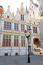
Brugse Vrije

The Brugse Vrije was a castellany in the county of Flanders, often called in English "the Franc of Bruges". It included the area around Bruges, and was bordered by the North Sea, the Westerschelde and the Yser river. The city of Bruges was separated from the castellany in 1127. Since then the city and the Vrije were considered as separate customary law areas. The Brugse Vrije was a rich agricultural region. It had its own burgrave, who was seated at the Burg, a square in Bruges, and became part of the Four Members of Flanders at the end of the 14th century, together with the three major cities of Ghent, Bruges and Ypres. The Brugse Vrije sat in the meetings of the States of Flanders.
Excerpt from the Wikipedia article Brugse Vrije (License: CC BY-SA 3.0, Authors, Images).Brugse Vrije
Burg, Bruges Brugge-Centrum (Brugge)
Geographical coordinates (GPS) Address Nearby Places Show on map
Geographical coordinates (GPS)
| Latitude | Longitude |
|---|---|
| N 51.208377777778 ° | E 3.2275694444444 ° |
Address
't Brugse Vrije
Burg
8000 Bruges, Brugge-Centrum (Brugge)
West Flanders, Belgium
Open on Google Maps


