Chadshunt
Civil parishes in WarwickshireStratford-on-Avon DistrictVillages in WarwickshireWarwickshire geography stubs

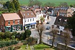
Chadshunt is a small village and civil parish in the Stratford-on-Avon district, in the county of Warwickshire, England. Chadshunt is located in between the villages of Gaydon (where population can be found), and Kineton. It grew up around the mill stream alongside Watery Lane. The former Yarlington Mill is now a private residence. Chadshunt has a church called All Saints Church.
Excerpt from the Wikipedia article Chadshunt (License: CC BY-SA 3.0, Authors, Images).Chadshunt
Watery Lane, Stratford-on-Avon Chadshunt CP
Geographical coordinates (GPS) Address Nearby Places Show on map
Geographical coordinates (GPS)
| Latitude | Longitude |
|---|---|
| N 52.166666666667 ° | E -1.4833333333333 ° |
Address
Watery Lane
Watery Lane
CV35 0EJ Stratford-on-Avon, Chadshunt CP
England, United Kingdom
Open on Google Maps


