Miami-Opa Locka Executive Airport

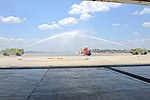
Miami-Opa Locka Executive Airport (IATA: OPF, ICAO: KOPF, FAA LID: OPF) (formerly Opa-locka Airport and Opa-locka Executive Airport until 2014) is a joint civil-military airport located in Miami-Dade County, Florida 11 mi (18 km) north of downtown Miami. Part of the airport is in the city limits of Opa-locka. The National Plan of Integrated Airport Systems for 2011–2015 called it a general aviation reliever airport.The FAA-contract control tower is manned from 7:00 AM to 11:00 PM. The airport has four fixed-base operators. It is owned by Miami-Dade County and operated by the Miami-Dade Aviation Department.The sole remaining military activity at the airport is Coast Guard Air Station Miami, operating from federal property not deeded to the county. It hosts EADS HC-144 Ocean Sentry turboprops; and MH-65 Dolphin helicopters for coastal patrol, deployment aboard medium endurance and high endurance coast guard cutters, and air-sea rescue. Much of CGAS Miami's facilities were built during World War II as part of Naval Air Station Miami. DayJet provided on-demand jet air charter services to 44 airports in 5 states; it filed for Chapter 7 bankruptcy liquidation in 2008. The airport is served by several cargo and charter airlines that use the U.S. customs facility. Maintenance and modification of airliners up to Boeing 747 size is carried out by several aviation firms.
Excerpt from the Wikipedia article Miami-Opa Locka Executive Airport (License: CC BY-SA 3.0, Authors, Images).Miami-Opa Locka Executive Airport
Northwest 42nd Avenue-37th Avenue Connector,
Geographical coordinates (GPS) Address External links Nearby Places Show on map
Geographical coordinates (GPS)
| Latitude | Longitude |
|---|---|
| N 25.9075 ° | E -80.278333333333 ° |
Address
Opa-locka Executive Airport
Northwest 42nd Avenue-37th Avenue Connector
33054
Florida, United States
Open on Google Maps


