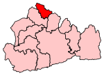
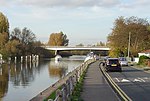
River Ash, Surrey

The River Ash is a small, shallow river in Surrey, England. Its course of 10 kilometres (6.2 mi) is just outside Greater London. Work has been carried out to re-align, clear, build up a small, Littleton head of water and create two backwaters. One backwater dates to the medieval period; the other to the 1990s decade. It flows as one of the six distributaries of the River Colne from the south of Staines Moor immediately south of the Staines Bypass eastwards through the rest of the borough of Spelthorne before meeting the River Thames. It is not navigable to craft and is rich in plant and insects, particularly reeds, diverse sedges (many of which commonly called bulrushes), pond-skaters, amphibians and lepidoptera (moths and butterflies). It enhances the Ash Link Nature Reserve, Studios Walk woodland biodiversity site and two parks. It is recognised as a key ecological feature within its Borough.
Excerpt from the Wikipedia article River Ash, Surrey (License: CC BY-SA 3.0, Authors, Images).River Ash, Surrey
Hitchcock Close, Borough of Spelthorne
Geographical coordinates (GPS) Address Nearby Places Show on map
Geographical coordinates (GPS)
| Latitude | Longitude |
|---|---|
| N 51.407 ° | E -0.469 ° |
Address
Hitchcock Close
Hitchcock Close
TW17 0QT Borough of Spelthorne
England, United Kingdom
Open on Google Maps


