D11 motorway (Czech Republic)
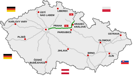
The D11 motorway (Czech: Dálnice D11) is a highway in the Czech Republic. Plans to build a highway connecting Prague and Hradec Králové date from 1938; construction finally began in 1978. Today it consists of one continuous segment Praha - Poděbrady - Libice nad Cidlinou - Libčany - Plačice - Plotiště - Smiřice - Jaroměř and last segment Jaroměř - Trutnov - border CZ/PL (polish expressway S3) is planned and waits for permits. It is part of European route E67 "Via Baltica" from Prague in the Czech Republic to Helsinki in Finland by way of Poland, Lithuania, Latvia, and Estonia. Three lanes in each direction are planned by 2025 between Prague and Jirny (8 km) and to Poděbrady after 2025.
Excerpt from the Wikipedia article D11 motorway (Czech Republic) (License: CC BY-SA 3.0, Authors, Images).D11 motorway (Czech Republic)
D11, okres Nymburk
Geographical coordinates (GPS) Address Nearby Places Show on map
Geographical coordinates (GPS)
| Latitude | Longitude |
|---|---|
| N 50.116561111111 ° | E 15.202502777778 ° |
Address
D11
289 07 okres Nymburk
Central Bohemia, Czechia
Open on Google Maps


