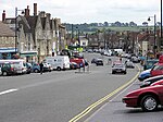
Old Sodbury

Old Sodbury is a small village and former civil parish in the valley of the River Frome just below and to the west of the Cotswold escarpment and to the east of Chipping Sodbury and Yate, now in the parish of Sodbury, in the South Gloucestershire district, in the ceremonial county of Gloucestershire, England. It is situated in the Hundred of Grumbald's Ash. The village extends from Chipping Sodbury in the West to the Cotswold Edge in the East and is on the Cotswold Way. The Badminton Road (A432) winds eastwards towards Badminton, Gloucestershire through the village, up to the Cross Hands junction with the A46, which runs along the top of the Cotswold escarpment from Bath to Stroud. In 1931 the parish had a population of 837. On 1 April 1946 the parish was abolished to form Sodbury.The village lies on an old coaching route, and is much more ancient than its westerly neighbour, Chipping Sodbury: hence the name 'Old' Sodbury.
Excerpt from the Wikipedia article Old Sodbury (License: CC BY-SA 3.0, Authors, Images).Old Sodbury
Cotswold Villas,
Geographical coordinates (GPS) Address Nearby Places Show on map
Geographical coordinates (GPS)
| Latitude | Longitude |
|---|---|
| N 51.533601 ° | E -2.356147 ° |
Address
Cotswold Villas
BS37 6NF , Sodbury
England, United Kingdom
Open on Google Maps


