place

Willamette Park

1929 establishments in OregonParks in Portland, OregonProtected areas established in 1929South Portland, Portland, OregonUrban public parks
Willamette Park Portland

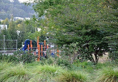
Willamette Park is a city park of about 26 acres (11 ha) in south Portland, in the U.S. state of Oregon. Located at Southwest Macadam Avenue and Nebraska Street, the park includes a boat dock and ramp, paved and unpaved paths, picnic areas, restrooms, a dog off-leash area, playground, soccer field, and tennis courts.

Excerpt from the Wikipedia article Willamette Park (License: CC BY-SA 3.0, Authors, Images).

Willamette Park
Willamette Greenway, Portland South Portland

Geographical coordinates (GPS) Address Nearby Places
placeShow on map

Wikipedia: Willamette ParkContinue reading on Wikipedia

Geographical coordinates (GPS)

Latitude Longitude
N 45.474166666667 ° E -122.66888888889 °
placeShow on map

Address

Willamette Greenway

Willamette Greenway
97239 Portland, South Portland
Oregon, United States
mapOpen on Google Maps

Willamette Park Portland
Share experience

Nearby Places

Stephens Creek (Oregon)

Stephens Creek, a 2-mile (3 km) tributary of the Willamette River, flows entirely within the city of Portland in the U.S. state of Oregon. Beginning in the neighborhood of Hillsdale, it runs generally east through residential and commercial neighborhoods as well as patches of forest and parkland to join the Willamette slightly north of the Sellwood Bridge. Its course passes under Interstate 5 and down the canyon followed by Southwest Taylors Ferry Road. Stephens Creek enters the river at Willamette Moorage Park, which is part of a 35-acre (14 ha) group of natural areas called the South Portland Riverbank. The natural areas include Butterfly Park and Willamette Park as well as the moorage park and other public land parcels.Stephens Creek Nature Park, a 3.38-acre (1.37 ha) protected area at Southwest Bertha Boulevard and Chestnut Street, is near the creek's headwaters. It provides open space and a plant and animal refuge in an urban setting. Downstream, the Portland Bureau of Environmental Services and its partners completed work in 2008 to improve habitat for endangered fish species such as Chinook salmon that frequent the creek near its mouth.The Stephens Creek headwaters project was completed in 2007. Through an innovative pilot project called Green Streets, the headwaters basin of Stephens Creek was improved through the use of bioswales, which are specially engineered ditches on the side of the street, receive rain flowing off the asphalt. Rocks and native plants slow the water down. Water is directed to a wetland area acquired as part of the project. This allows rain to seep underground, cleans the water of contaminants, and moderates the water flows in the creek. This was a joint project between the local neighborhood residences and the City of Portland.

Butterfly Park
Butterfly Park

Butterfly Park is a city park of about 1 acre (0.4 ha) in south Portland, in the U.S. state of Oregon. Located at 7720 Southwest Macadam Avenue, the park includes a natural area and walking paths near the Willamette River. The natural area provides important habitat for butterflies, including mourning cloaks and orange sulphurs.The Greenway Trail, part of the 40-Mile Loop, links Butterfly Park to Miles Place and Willamette Park on the north as well as the Willamette Moorage Natural Area, the Sellwood Bridge, and Powers Marine Park, all on the south. Slightly south of Butterfly Park, Stephens Creek empties into the Willamette. Oaks Amusement Park and Sellwood Riverfront Park are on the river's east bank, opposite Butterfly Park.At the park entrance, a rock garden near an interpretive sign features columbines, penstemon, fireweed, and other flowering plants. Vegetation in the park, once dominated by Himalayan blackberries, includes native grasses, wildflowers, and dogwood. Cedar waxwings, killdeer, orioles, chickadees, and other birds frequent the park. A bench along the trail offers views of Ross Island and other spots along the river.It took about 10 years to organize and develop the park, formerly a "derelict patch of land" near the Macadam Bay Club, a residential houseboat community. The South Portland Neighborhood Association worked with Portland Parks & Recreation to complete the work. The park is "one of the region's smallest, but most biologically productive" greenspaces.