place

Moel Cynghorion

Gwynedd geography stubsHewitts of WalesLlanberisMarilyns of WalesMountains and hills of Gwynedd
Mountains and hills of SnowdoniaNuttalls
Cyngortfu
Cyngortfu

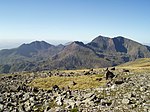
Moel Cynghorion (the Hill of the Councillors) is a mountain in Snowdonia, North Wales. It lies two miles north-west of Snowdon, and forms part of the Moel Eilio Horseshoe walk. The summit is situated on a wide plateau, marked by a pile of stones. The southern slopes are gentle, while the northern aspect is precipitous. The summit has close views of Clogwyn Du'r Arddu and Snowdon (Yr Wyddfa). Views from the summit can extend as far as Holyhead in Anglesey to nearby towns and villages in Gwynedd such as Caernarfon, Llanrug and Llanberis. On a clear day the Wicklow Mountains in Ireland can be seen across the Irish Sea, at a distance of approximately 80 miles.

Excerpt from the Wikipedia article Moel Cynghorion (License: CC BY-SA 3.0, Authors, Images).

Moel Cynghorion
Snowdon Ranger Path,

Geographical coordinates (GPS) Address Nearby Places
placeShow on map

Wikipedia: Moel CynghorionContinue reading on Wikipedia

Geographical coordinates (GPS)

Latitude Longitude
N 53.08514 ° E -4.11265 °
placeShow on map

Address

Snowdon Ranger Path

Snowdon Ranger Path
LL54 7YS
Wales, United Kingdom
mapOpen on Google Maps

Cyngortfu
Cyngortfu
Share experience

Nearby Places

Paddy Buckley Round
Paddy Buckley Round

The Paddy Buckley Round, also known as the Welsh Classical Round, is a long distance fell running challenge in Snowdonia, Wales. The route is a circuit of just over 100 km long taking in some 47 summits. The Round has the reputation of being somewhat tougher to complete than its English Lake District equivalent, the Bob Graham Round. Although no official time limit is set, an arbitrary 24 hours is applied, although the first completer exceeded the original aim of 24 hours. Runners may start at any point on the circular route (finishing at the same place) and may run the course in either a clockwise or anticlockwise direction. The route takes in the well-known high mountain ranges of Snowdon, the Glyderau and the Carneddau as well as the slightly less visited ranges of Moel Siabod, the Moelwynion, Moel Hebog and the Nantlle Ridge. The route was devised by the eponymous Paddy Buckley and first completed in 1982 by Wendy Dodds. The selection of summits that must be visited is somewhat arbitrary and no rules appear to have been applied in selecting them. Generally, it takes in the major peaks of the ranges that are being crossed, then any minor tops that are passed along the way are also included. Some of these tops really are just bumps on the ridge and not really summits in their own right at all. The fastest known completion of the round was, for many years, by Mark Hartell in 18 hours 10 minutes. On 4 May 2008, this time was matched by Chris Near of Eryri Harriers. This old record was broken in July 2009 by Tim Higginbottom who completed the Round in a time of 17 hours and 42 minutes. This was further reduced in 2019 by Damian Hall with 17 hours 31 minutes, and again on 30 August 2020 by Matthew Roberts with a time of 16 hours 38 minutes. Kim Collison set a new best time of 16 hours 20 minutes in April 2021. A year later, in April 2022, a new record was set by Finlay Wild who completed the round solo and unsupported in a time of 15 hours 14 minutes.The women's record is held by Jasmin Paris with a time of 18 hours and 33 minutes, set in 2016.The book "The Welsh Three Thousand Foot Challenges: A Guide for Walkers and Hill Runners" describes a version of the route which avoids the slate quarries, which the fastest line utilises, and also suggests attempting it as a four-day backpacking (lightweight camping) excursion rather than a one-day run.

Llyn Peris
Llyn Peris

Llyn Peris is a lake in Snowdonia, Wales, approximately 1.8 km long and situated close to the villages of Llanberis and Nant Peris, and the smaller twin of Llyn Padarn. The lake was formed glacially and is an example of a moraine-dammed lake. Llyn Peris is named after Saint Peris, an early Christian saint of whom little is known. The lake is flanked on one side by the mountain Elidir Fawr and the former slate quarry of Dinorwig. Above the opposite bank are the hills of Derlwyn and Clogwyn Mawr and a rock formation known as the Lady of Snowdon, due to its resemblance to a human face. The ruins of Dolbadarn Castle are also located on a mound above the lake. The lake now forms the lower reservoir of Dinorwig power station, and the administrative buildings for the station are situated on the lake shore. Water is released into the lake from Marchlyn Mawr (the upper reservoir) to produce electricity during periods of peak demand. This water is, in turn, pumped back to the upper reservoir using electricity purchased at off-peak periods. The water level of the lake therefore varies considerably, depending on UK electricity demand. Excess water from the lake drains into Llyn Padarn. During construction of the power station, when the capacity of the lake was increased considerably at this time, with the removal of a large quantity of slate waste, rare Welsh Arctic char fish were removed to four other lakes in the neighbouring Carneddau mountains, namely Ffynnon Llugwy, Llyn Cowlyd, Llyn Melynllyn and Llyn Dulyn, where they are still to be found. Although Llyn Peris itself was not restocked, some char have found their way back to the lake. Parts of the lake shore are designated as a Site of Special Scientific Interest for Glacial Geology.