place

Odd Fellows Rest Cemetery

1849 establishments in LouisianaBuildings and structures in New OrleansCemeteries established in the 1840sCemeteries on the National Register of Historic Places in LouisianaLouisiana Registered Historic Place stubs
National Register of Historic Places in New OrleansOdd Fellows buildings in LouisianaOdd Fellows cemeteries in the United StatesRenaissance Revival architecture in LouisianaUse American English from November 2019Use mdy dates from November 2019Vague or ambiguous time from November 2022
OddFellowsRestGateNOLA1

The Odd Fellows Rest Cemetery is located in New Orleans, Louisiana. Opened in 1849, Odd Fellow Rest Cemetery is one of a group of historic cemeteries in New Orleans. The cemetery features Renaissance architecture and Exotic Revival architecture. It was listed on the National Register of Historic Places in May 1980. Odd Fellows Rest Cemetery is not open to the public.

Excerpt from the Wikipedia article Odd Fellows Rest Cemetery (License: CC BY-SA 3.0, Authors, Images).

Odd Fellows Rest Cemetery
Canal Street, New Orleans Hollygrove

Geographical coordinates (GPS) Address Nearby Places
placeShow on map

Wikipedia: Odd Fellows Rest CemeteryContinue reading on Wikipedia

Geographical coordinates (GPS)

Latitude Longitude
N 29.981666666667 ° E -90.110555555556 °
placeShow on map

Address

Canal Street 5055
70119 New Orleans, Hollygrove
Louisiana, United States
mapOpen on Google Maps

OddFellowsRestGateNOLA1
Share experience

Nearby Places

Holt Cemetery
Holt Cemetery

Holt Cemetery is a potter's field cemetery in New Orleans, Louisiana. It is located next to Delgado Community College, behind the right field fence of the college's baseball facility, Kirsch-Rooney Stadium. The cemetery is named after Dr. Joseph Holt, an official of the New Orleans Board of Health (famously involved with city health issues concerning Storyville, the Red-light district of New Orleans) who officially established the cemetery in the 19th century. Holt Cemetery is one of the Historic Cemeteries of New Orleans. The cemetery was established in 1879 to inter the bodies of poor or indigent residents of the city. Funeral processions to Holt Cemetery were generally around, rather than through, the city. The original cemetery was 5.5 acres, and it was expanded in 1909 to 7 acres. Nearly all of the tombs are in-ground burials. As established, ownership of the graves at Holt Cemetery were given to the families of the deceased for the cost of digging the grave and subsequent maintenance of the plot.Most of the graves and tombs at Holt Cemetery were not commercially or professionally produced but were instead fabricated by families of the deceased, giving the cemetery a strong personal touch.The cemetery contains the remains of known and unknown early blues and jazz musicians, including Babe Stovall, Jessie Hill and Charles "Buddy" Bolden. The battered remains of Robert Charles, at the center of the 1900 New Orleans race riot were briefly interred there, then dug up, and incinerated. Later, in 1973, four victims of the UpStairs Lounge arson attack, Ferris LeBlanc and three unidentified males, were buried in a mass grave at the cemetery.Over the years, Holt Cemetery has been a destination of ghost hunters, with frequent incidents of grave-robbing and reports of Voodoo and Santería rituals.The city of New Orleans conducted $450,000 in repairs and upgrades to Holt Cemetery in 2013 and 2014. However, the graves and tombs themselves remain in a state of significant neglect, with human remains being evident. New burials continue at Holt Cemetery, and the graves show evidence for frequent visits and various cultural materials.The word "Holt" means "Dead" in Hungarian. The name "Holt" is of Proto-Germanic origin meaning a small wood or grove of trees.

Bayou Metairie
Bayou Metairie

Bayou Metairie was a stranded distributary bayou that was located in present-day New Orleans, Louisiana, USA, and Jefferson Parish, Louisiana, USA, that extended from the area known as River Ridge to Bayou St. John. Bayou Metairie was filled in during the late 19th century and early 20th century although remnants of Bayou Metairie persist. The geologic record indicates that the Mississippi River 2600 years ago followed a course that became Bayou Metairie. This flow pattern gave rise to river banks through alluvial deposition in that location. With time, the course of the river shifted to its present day location, leaving behind a stranded waterway that was Bayou Metairie. Its river banks of its past course remained as the long narrow strip of higher ground that is known as the Metairie - Gentilly Ridge. This ridge as it followed Bayou Metairie was as much as a mile wide at its beginning, becoming much narrower as it progressed eastward, with a height of approximately seven feet. Water flow from the Mississippi River into Bayou Metairie was intermittent until approximately the year 1700 when it had ceased completely.Bayou Metairie meandered 20 miles eastward through present-day Jefferson Parish and Orleans Parish, following a path approximately parallel to the present course of the Mississippi River. Eventually Bayou Metairie developed a northward outlet to Lake Pontchartrain, the outlet becoming known as Bayou St. John. The sections east of Bayou St. John came to be known as Bayou Savage and Bayou Gentilly. The locations of these distributaries and the Metairie - Gentilly Ridge can be seen in the 1849 Sauvé's Crevasse map. 
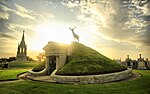
Bayou Metairie and the narrow, elevated banks that comprise the Metairie - Gentilly Ridge had long been used by indigenous people in pre-colonial times. Subsequently, the land on the ridge was mostly used for small farms and gardens, being fertile soil on high ground, in centuries past of the region. Only intermittently was Bayou Metairie navigable, and then only by small boats, depending on wind and tide. Small colonial farms were established by 1708, pre-dating the city of New Orleans. In the early history of New Orleans, smugglers and runaway slaves made use of Bayou Metairie and the accompanying ridge.As urban development continued in the region in the late 19th century and early 20th century, Bayou Metairie was filled in, with only remnants persisting by the early 1900s. Some of the remnants include the area around Dueling Oaks in New Orleans City Park and the lagoons in the lower part of City Park. Early real estate developers promoted the location based on its easy access to New Orleans. The Metairie - Gentilly Ridge, which followed part of the course of Bayou Metairie, is presently occupied by Metairie Road in Jefferson Parish, Louisiana.Indigenous people in the region referred to Bayou Metairie as "Bayou Tchoupitoulas", while Spanish settlers knew it as "Arroyo de la Alqueria". French settlers referred to the Metairie - Gentilly Ridge as "Chemin de la Métairie".