place

Millwood, Virginia

Clarke County, Virginia geography stubsUnincorporated communities in Clarke County, VirginiaUnincorporated communities in VirginiaUse mdy dates from July 2023
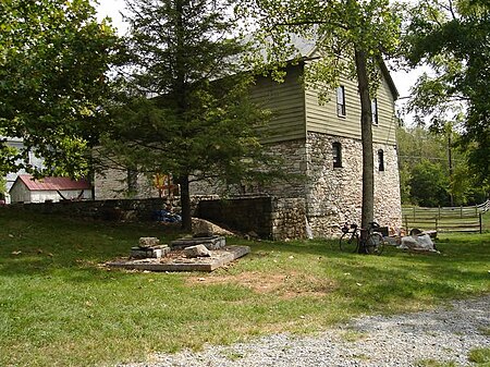
Burwell morgan mill
Burwell morgan mill

Millwood is an unincorporated community located in Clarke County, Virginia, United States. Millwood is the home of many of Clarke County's most historic sites including the Burwell-Morgan Mill (1785), Carter Hall (1792), the Greenway Historic District, Long Branch (1811), Old Chapel (1790), and the River House. Project HOPE is based at Carter Hall.

Excerpt from the Wikipedia article Millwood, Virginia (License: CC BY-SA 3.0, Authors, Images).

Millwood, Virginia
Cunningham Lane,

Geographical coordinates (GPS) Address Nearby Places
placeShow on map

Wikipedia: Millwood, VirginiaContinue reading on Wikipedia

Geographical coordinates (GPS)

Latitude Longitude
N 39.069444444444 ° E -78.037777777778 °
placeShow on map

Address

Cunningham Lane 43
22620
Virginia, United States
mapOpen on Google Maps

Burwell morgan mill
Burwell morgan mill
Share experience

Nearby Places

Millwood Commercial Historic District

Millwood Commercial Historic District is a national historic district located at Millwood, Clarke County, Virginia. Millwood developed after the American Revolutionary War around the Burwell-Morgan Mill (1782-1785; listed in the NRHP since 1969), along Spout Run and one of the largest in the area. It is near several roads important in the colonial era, including Route 17 and Route 340. Col. Nathaniel Burwell (1750-1814), who owned over 5,000 acres in the agriculturally productive area constructed it with General Daniel Morgan (1736-1802) as his business partner. The mill had become derelict by the 1940s, when it was acquired by the Clarke County Historical Association, which restored it and operates it as a living history museum. This district includes 10 additional contributing buildings in the village of Millwood. They include a log building (c. 1800) that was originally part of a tannery along Spout Run and later used a tollhouse; a log building (c. 1805) that was used to store liquor and was later converted into a residence; the frame miller's house (c. 1830 located directly south of the mill); a brick store (c. 1836 that partially burned in 1935 and still functions as a store). The remaining buildings are associated with the village's commercial core in the late 19th and early 20th centuries: a 1-story stone and frame outbuilding that may have once been used as a cooper's shop; a frame, 1 ½-story, late-19th century commercial building; a 1 ½-story frame commercial building that once housed the Millwood post office (c. 1900); a 1-story, formed concrete block building (constructed ca. 1928, as a car showroom and now used as an antique shop); and a 1-story, brick former service station (c. 1930) that has housed the post office since 1985. The commercial buildings are directly visible from the mill and the district was drawn to exclude residential, religious and educational buildings.It was listed on the National Register of Historic Places in 2006. In 2014, the Chapel Rural Historic District was added to the National Register, and had been added to the Virginia Historic Register, encompassing nearly 11,500 acres and nearly 700 contributing properties, including residential, educational and religious buildings excluded by this entry.

Orland E. White Research Arboretum

The Orland E. White Arboretum, officially the State Arboretum of Virginia, is an arboretum (172 acres) operated by the University of Virginia as part of the Blandy Experimental Farm (700 acres). It is located at 400 Blandy Farm Lane, Boyce, Virginia, and open to visitors daily from dawn to dusk without fee. Graham F. Blandy bequeathed 700 acres of his 900-acre estate known as Blandy Farm to Virginia to use horticultural research. The farm's first director, Orland Emile White, established the arboretum a year after Blandy's death and upon White's retirement in 1955 it was named in his honor. Early research focused on cytological reconstruction of plant phylogenies and the consequences of irradiation-induced mutations. It became the official State Arboretum in 1986. Today the arboretum is maintained primarily for environmental research and education for university, K-12 and general audiences. It contains more than 8,000 trees and woody shrubs, representing over 1,000 species and cultivated varieties of plants in 50 plant families. Of particular interest are its collection of boxwood cultivars (said to be the largest in North America) and its pine collection, representing over half of the world's species. Other arboretum features include a Ginkgo biloba grove (more than 300 trees), the Virginia Native Plant Trail (established 1997), extensive meadows, and plantings of azalea, beech, buckeye, catalpa, Cedar of Lebanon, crabapple, holly, lilac, linden, magnolia, maple, stuartia, and viburnum.

Blandy Experimental Farm Historic District

Blandy Experimental Farm Historic District is a national historic district located adjacent to The Tuleyries at Boyce, Clarke County, Virginia. It encompasses 15 contributing buildings, 1 contributing site, and 1 contributing structure. They include a large, two-story, brick slave's quarters built about 1825; a stone and brick stables that was later converted into a dwelling; a turn-of-the-20th-century farmhouse and its associated agricultural and domestic related outbuildings; a late-19th century vernacular hall-parlor-plan house; two historic dwelling sites; as well as orchards and fields of improved pasture.Graham F. Blandy bequeathed 700 acres of his approximately 900-acre estate to the University of Virginia, which accepted it after his death in 1926. The University began its program of agricultural biology at Blandy in 1927, and converted part of the landscape into an arboretum. Dr. Orland E. White planted began planting the Arboretum in 1929, and upon his retirement in 1955 it was named the Orland E. White Research Arboretum. In 1986, the Virginia general assembly designated the property the State Arboretum of Virginia.The slaves' quarters, referred to as the Quarters, was converted into laboratories and student and faculty housing. In 1941, the Quarters building was greatly enlarged with the addition of three Colonial Revival wings. This addition created a U-shaped building with the original Quarters section as the east wing. A research greenhouse was built at the same time.It was listed on the National Register of Historic Places in 1992.