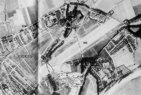
RAF Christchurch

Royal Air Force Christchurch or more simply RAF Christchurch is a former Royal Air Force satellite station and was located southeast of the A337/B3059 junction in Somerford, Christchurch, Dorset, England. Christchurch Airfield was a civil airfield that started operation from 1926, enlarged for wartime operations in 1941, Christchurch was used during World War II by the Royal Air Force and the United States Army Air Forces Ninth Air Force. It returned to civilian flying postwar before being taken over by what became British Aerospace to manufacture jet fighters and civilian airliner types. The airfield complex was finally closed down and demolished in 1966 when housing was built on the site.
Excerpt from the Wikipedia article RAF Christchurch (License: CC BY-SA 3.0, Authors, Images).RAF Christchurch
Glider Close,
Geographical coordinates (GPS) Address Nearby Places Show on map
Geographical coordinates (GPS)
| Latitude | Longitude |
|---|---|
| N 50.739722222222 ° | E -1.7394444444444 ° |
Address
Glider Close
BH23 4FT , Highcliffe and Walkford
England, United Kingdom
Open on Google Maps


