Higher Common Ground
Cricket grounds in KentSport in Royal Tunbridge WellsSports venues completed in 1844Use British English from July 2019

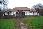
Higher Common Ground is a cricket ground on Tunbridge Wells Common in the town of Royal Tunbridge Wells in Kent. It was used as a ground by Kent County Cricket Club in the 19th century and is the home ground of Linden Park Cricket Club. The ground is located in the central area of Tunbridge Wells Common, close to the Wellington Rocks, an outcrop of Ardingly Sandstone laid down in the Lower Cretaceous period. It is on Fir Tree Road, around 250 metres (0.16 mi) from the A264 road to the north and 500 metres (0.31 mi) from the A26 road to the south and east. The centre of Tunbridge Wells is 600 metres (0.37 mi) east of the ground.
Excerpt from the Wikipedia article Higher Common Ground (License: CC BY-SA 3.0, Authors, Images).Higher Common Ground
Fir Tree Lane, Tunbridge Wells Broadwater Down
Geographical coordinates (GPS) Address Nearby Places Show on map
Geographical coordinates (GPS)
| Latitude | Longitude |
|---|---|
| N 51.129 ° | E 0.253 ° |
Address
Upper Cricket Ground
Fir Tree Lane
TN4 8AH Tunbridge Wells, Broadwater Down
England, United Kingdom
Open on Google Maps

