place

Blyborough

Civil parishes in LincolnshireGrade I listed buildings in LincolnshireLincolnshire geography stubsUse British English from October 2014Villages in Lincolnshire
West Lindsey District
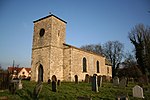
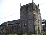
St Alkmunds Church, Blyborough

Blyborough is a village and civil parish in the West Lindsey district of Lincolnshire, England. The population of the civil parish at the 2011 census was 115. It lies on the B1398 road, 9 miles (14 km) east from Gainsborough, 16 miles (26 km) north from Lincoln and 3 miles (5 km) south from Kirton Lindsey. Blyborough's Grade I listed Anglican parish church is dedicated to the Anglo-Saxon saint and martyr, Alkmund of Derby. Built in the early 13th century, it was partially rebuilt in 1877 by James Fowler.Two Grade II listed village buildings are Blyborough Grange Farmhouse and Blyborough Hall. The hall was built in the early 18th century and was for many generations the home of the Luard family, who acquired their wealth through sugar plantations in the West Indies.

Excerpt from the Wikipedia article Blyborough (License: CC BY-SA 3.0, Authors, Images).

Blyborough
West Lindsey

Geographical coordinates (GPS) Address Nearby Places
placeShow on map

Wikipedia: BlyboroughContinue reading on Wikipedia

Geographical coordinates (GPS)

Latitude Longitude
N 53.439445 ° E -0.597565 °
placeShow on map

Address


DN21 4HB West Lindsey
England, United Kingdom
mapOpen on Google Maps

St Alkmunds Church, Blyborough
Share experience

Nearby Places

Hemswell
Hemswell

Hemswell is a village and civil parish in the West Lindsey district of Lincolnshire, England. It is situated just north of the A631 on the Lincoln Cliff escarpment, 2 miles (3 km) west from Caenby Corner and 7 miles (11 km) east from Gainsborough. According to the 2001 Census it had a population of 309. In Domesday Hemswell is written as "Helmeswelle", a settlement of 37 households, which before 1086 was under the lordship of Earl Edwin.Aerial photographs have shown ancient medieval settlement on the edge of the village, and 18th-century enclosure maps indicate a larger village area than now exists and the site of a medieval church. earthworks have been defined through crop markings and hollow ways, ditched enclosures, embankments and foundations of buildings that indicate the existence of crofts. Hemswell Grade II* listed Anglican parish church is dedicated to All Saints. Originating in the 13th century it was partially rebuilt in 1764, when a new tower was added, and in 1858, when the rest of the church was replaced. An internal Early English three-bay north arcade remains, as does a 13th-century Decorated sedilia on the south wall of the chancel. The font bears the arms of the Monson family. A further listed church, St Edmund's on Spital-in-the-Street Road, is a converted 16th-century quarter sessions court house.Opposite the churchyard is a 19th-century maypole of wood and wrought iron with painted red white and blue stripes. It is one of the oldest in England, and danced round each May Day during the village May Day Fete. On Church Street is the listed early 19th-century Post Office, now non-operational, and Manor Farmhouse, originally 17th-century. On Spital-in-the-Street Road is the early 17th-century Spital Almshouse, now a cottage, and its barn, previously a hospice.RAF Hemswell was located just outside the village from 1937 until it closed in 1967. The site and buildings were subsequently redeveloped into a private trading estate which became the new civil parish of Hemswell Cliff.