place

Laurentian High School

1958 establishments in Ontario2005 disestablishments in OntarioBuildings and structures demolished in 2009Commons link is the pagenameDefunct schools in Ottawa
Demolished buildings and structures in OntarioEducational institutions disestablished in 2005Educational institutions established in 1958
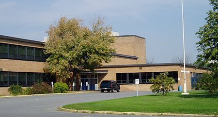
Laurentian HS
Laurentian HS

Laurentian High School was a former Ottawa high school. It was located on Baseline Rd. at the corner of Clyde, in the city's West End. The school opened in 1958. LHS provided education to grade 9 through 12 through an unsemestered curriculum as established by the Ontario Ministry of Education 1958–2005. LHS provided grade 13 from 1961 to 2003. The property is located at one edge of River Ward, with College Ward and Knoxdale-Merivale Ward adjacent.

Excerpt from the Wikipedia article Laurentian High School (License: CC BY-SA 3.0, Authors, Images).

Laurentian High School
Baseline Road, (Old) Ottawa River

Geographical coordinates (GPS) Address Nearby Places
placeShow on map

Wikipedia: Laurentian High SchoolContinue reading on Wikipedia

Geographical coordinates (GPS)

Latitude Longitude
N 45.3632 ° E -75.7379 °
placeShow on map

Address

Walmart Supercentre

Baseline Road 1375
K2C 3G1 (Old) Ottawa, River
Ontario, Canada
mapOpen on Google Maps

Laurentian HS
Laurentian HS
Share experience

Nearby Places

City View, Ottawa

City View (also known as St. Claire Gardens) is a neighbourhood in College Ward in the west end of the city of Ottawa, Ontario, Canada. It is located within the former city of Nepean. Most of the homes in it were built from the 1930s to the 1960s. By the 2000s some of the home were demolished and built into new ones; and they still are today. The area existed as a police village from 1954 to 1974. Its boundaries at the time were: North: the former Ottawa city limits (parallel to Baseline Road) to the north; East: Clyde Avenue until its intersection with Merivale, then east to a line behind the homes on the east side Gibey Dr then south to Capilano Dr then west to Merivale then south to the southern boundary; South: Meadowlands Drive West: The now in-filled section of Pinecrest creek behind the homes on the west side of Thatcher Street to David Dr and continuing east in a straight line past Withrow Avenue until what is now Lentini Way and then due north along the eastern boundary of what is now Algonquin College.Due to its older history, the neighbourhood is set up with a grid pattern of streets. According to the Canada 2011 Census, the population of this area was approximately 3,321. The neighbourhood is right next to Algonquin College, and contains Elizabeth Wynwood High School. It contains a number of small parks; St. Nicholas Park, Starwood Park, City View Park and Doug Frobel Park. The neighbourhood also contains the Nepean Museum. The City View Curling Club is on the other side of Merivale on Capilano Drive.

Carlington
Carlington

Carlington is a neighbourhood located in River Ward in the west-end of Ottawa, Ontario, Canada. The community association boundaries are Clyde Avenue to the west, Carling Avenue and the Queensway to the north, Fisher Avenue to the east and the Central Experimental Farm Pathway to the south. According to the Canada 2016 Census, the total population for this area was 11,363.Carlington was first settled in the early 1920s. It contains less than 435 older pre-1945 homes. Some 2,000 dwellings were built from 1945 to 1960. The houses built in the time period immediately following World War II were meant for returning veterans and are therefore known as "war homes" or "veteran homes". Many of the street names in the neighbourhood also reflect this military heritage (e.g. Viscount Ave, Admiral Ave, General Ave, Marshall Ave, Veteran Ave, Crerar Ave.). From 1961 to 1970, 1,440 homes and apartments were built and from 1971 to 1980, another 1,380. After 1981, the construction of new dwellings sharply dropped to less than 400 for the remainder of the 20th century. Today there are new homes being built as some veterans' homes are demolished. The neighbourhood is home to Westgate Shopping Centre and the Royal Ottawa Hospital. Merivale Road is Carlington's traditional main street and goes through the centre of residential Carlington. There are five places of worship: St. Elizabeth's of the Visitation Roman Catholic Church, Église Catholique Romain de Saint-Bonaventure, Church of God of Prophecy, Kehillat Beth Israel synagogue and St Tekle Haimanot Ethiopian Orthodox Tewahedo Church, the only Ethiopian Orthodox church in Ottawa. The Carlington Business Area is west of Kirkwood, north of Carlington Hill, south of the Queensway (417), and east of Maitland. The main business streets are Laperierre and Woodward.