place

St Andrew's Church, Woodwalton

12th-century church buildings in England13th-century church buildings in England14th-century church buildings in England16th-century Church of England church buildingsChurches preserved by the Friends of Friendless Churches
English Gothic architecture in CambridgeshireGrade II* listed churches in CambridgeshireRedundant churchesUse British English from February 2023
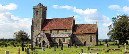
St Andrew's Church Woodwalton

St Andrew's Church is a redundant Anglican church standing in an isolated position in fields about 2 kilometres (1.2 mi) to the north of the village of Woodwalton (often Wood Walton) in Huntingdonshire, Cambridgeshire, England. It is about 200 metres (219 yd) to the east of the East Coast Main Line and is visible from the passing trains. The church is recorded in the National Heritage List for England as a designated Grade II* listed building, and is under the care of the Friends of Friendless Churches. As of 2010 it is not regularly open to visitors because its foundations are moving and it is unsafe.

Excerpt from the Wikipedia article St Andrew's Church, Woodwalton (License: CC BY-SA 3.0, Authors, Images).

St Andrew's Church, Woodwalton
New Road, Huntingdonshire

Geographical coordinates (GPS) Address External links Nearby Places
placeShow on map

Wikipedia: St Andrew's Church, WoodwaltonContinue reading on Wikipedia

Geographical coordinates (GPS)

Latitude Longitude
N 52.4241 ° E -0.2237 °
placeShow on map

Address

St Andrew's

New Road
PE28 5YT Huntingdonshire
England, United Kingdom
mapOpen on Google Maps

linkWikiData (Q7592380)
linkOpenStreetMap (157525289)

St Andrew's Church Woodwalton
Share experience

Nearby Places

Sawtry Abbey
Sawtry Abbey

Sawtry Abbey was a Cistercian abbey located between Sawtry and Woodwalton in Cambridgeshire, England. The abbey was founded in 1147 by Simon II de Senlis, Earl of Northampton, who was the grandson of Earl Waltheof and Judith, the niece of William the Conqueror who held the manor when the Domesday Survey was compiled. It is the only Cistercian abbey in the county.A colony of monks from Wardon Abbey in Bedfordshire joined the new monastery, which was founded as an independent abbey. Due to its proximity to other monasteries, disputes over tithes and land with the abbots of Ramsey and Thorney often occurred during the 13th century.During the 14th century, the abbot of Sawtry was often recorded as being in debt, although the exact cause is unknown. Indeed, very few documents relating to the abbey survive. The abbey was worth less than £200 a year, and at the Dissolution of the Monasteries the whole establishment was disbanded before December 1536. Of the 12 monks and 22 conversi only the abbot, William Angell, received a pension of £10.Following the dissolution in 1536, the church, conventual buildings, gate-house, bell tower and even the old parish church of Sawtry Judith were demolished. Stone was removed from the site as late as the 19th century.Excavations took place between 1907 and 1913. The layout of most of the abbey was recovered. The church was cruciform with short transepts and choir. The cloisters were located to the south and to their East was an infirmary or Abbots lodging. A guest house was situated south-west of the cloister. The earthworks were resurveyed and are well preserved. The site has been scheduled since 1954.

Middle Level Navigations

The Middle Level Navigations are a network of waterways in England, primarily used for land drainage, which lie in The Fens between the Rivers Nene and Great Ouse, and between the cities of Peterborough and Cambridge. Most of the area through which they run is at or below sea level, and attempts to protect it from inundation have been carried out since 1480. The Middle Level was given its name by the Dutch Engineer Cornelius Vermuyden in 1642, who subsequently constructed several drainage channels to make the area suitable for agriculture. Water levels were always managed to allow navigation, and Commissioners were established in 1754 to maintain the waterways and collect tolls from commercial traffic. The Middle Level Main Drain to Wiggenhall St Germans was completed in 1848, which provided better drainage because the outfall was lower than that at Salters Lode. Whittlesey Mere, the last remaining lake, was drained soon afterwards, using one of the first applications of John Appold's centrifugal pump, following its appearance at the Great Exhibition in 1851. Traffic on the network began to diminish after the opening of the railway through March in 1846, and fell dramatically in the early twentieth century. The last regular commercial traffic was the tanker barge Shellfen, which delivered fuel oil to pumping stations until 1971. As a result of the drainage, land levels continued to fall, and in 1934 the gravity outfall at Wiggenhall St Germans was replaced by a pumping station, with three diesel engines driving 8 ft 6 in (2.6 m) diameter pumps. Its capacity was increased in 1951, and again in 1969–70, when two of the engines were replaced by electric motors. Following over 50 hours of continuous running at maximum capacity in 1998, a new pumping station was commissioned. Work on it began in 2006, and when it was completed in 2010, it was the second largest pumping station in Europe. Much of the drainage of the Middle Levels relies on pumping, and the Commissioners manage over 100 pumping stations throughout the area. Interest in restoration of the Middle Levels for leisure traffic began in 1949, and the first significant work by volunteers occurred in 1972, when they worked on the restoration of Well Creek, which finally reopened in 1975. Since then, locks have been lengthened, to allow access by modern narrowboats, as they were built for Fen Lighters, which were only 49 feet (15 m) long. The southern reaches became more accessible in 2006, when a low Bailey bridge was raised by soldiers from the 39 Engineer Regiment. The system is managed by Commissioners, and they are the fourth largest navigation authority in Great Britain.