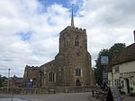
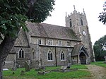
Waresley
EngvarB from June 2016Former civil parishes in CambridgeshireHuntingdonshireVillages in Cambridgeshire

Waresley is a village and former civil parish, now in the parish of Waresley-cum-Tetworth, in Cambridgeshire, England. Waresley lies approximately 11 miles (18 km) south of Huntingdon and 5 miles (8 km) south-east of the town of St Neots. Waresley is situated within Huntingdonshire which is a non-metropolitan district of Cambridgeshire as well as being a historic county of England. At the time of the 2001 census, the population of Waresley parish was 293. At the time of the 2011 Census the population was included in the Civil Parish of Little Gransden.
Excerpt from the Wikipedia article Waresley (License: CC BY-SA 3.0, Authors, Images).Waresley
Konrad-Adenauer-Ufer, Cologne Neustadt/Nord (Innenstadt)
Geographical coordinates (GPS) Address Nearby Places Show on map
Geographical coordinates (GPS)
| Latitude | Longitude |
|---|---|
| N 52.175 ° | E -0.173 ° |
Address
Bastei
Konrad-Adenauer-Ufer 80
50668 Cologne, Neustadt/Nord (Innenstadt)
Rhénanie-du-Nord-Westphalie, Allemagne
Open on Google Maps


