place

Alamere Falls

Landforms of Marin County, CaliforniaUse mdy dates from August 2022Waterfall stubsWaterfalls of California
AlamereFalls
AlamereFalls

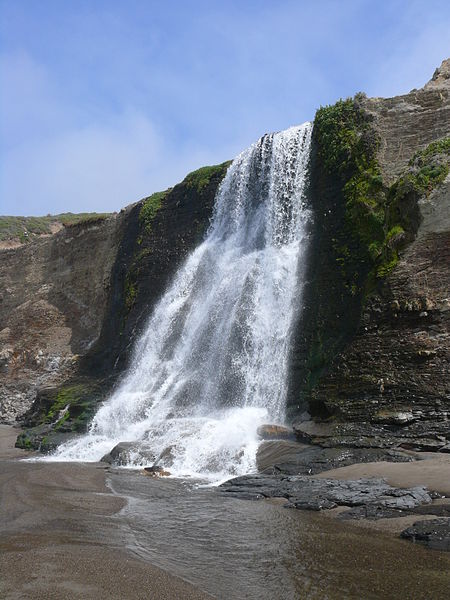
Alamere Falls is a waterfall in Point Reyes National Seashore, Marin County, California. Alamere Falls is a rare "tidefall", a waterfall that flows directly into the ocean. It is one of only two known tidefalls in California, the other being McWay Falls.Alamere Falls tumble over fragile shale cliffs at Alamere Creek Beach. Upstream of the main Alamere Falls is the upper Alamere Falls, consisting of three separate cascades. Together, these cascades are approximately 20–30 feet (6–9 m) in height. All of these waterfalls are fed by the Alamere Creek.Alamere Falls can be reached by following the Coast Trail from the Palomarin Trailhead at the end of Mesa Road out of Bolinas, California. After 2.5 mi (4.0 km), the trail passes two small lakes (Bass Lake and Pelican Lake). Bass Lake can be accessed by a side trail that leads to a rope swing, and hikers often stop for a swim during summer months. From the Palomarin Trailhead, the hike is 3.8 mi (6.1 km), one-way, to the top of the falls. To reach the bottom of the falls, the National Park Service advises hikers to continue to Wildcat Campground, descend to the beach and then walk 1.1 mi (1.8 km) south; the one-way distance from Palomarin Trailhead to the base of the falls is 6.6 mi (10.6 km). This trail leads along the beach, check out the tides before to figure out the exact time for low tide. Usually, the beach to Alamere Falls is unsafe to access at high tide, and hikers are frequently trapped.

Excerpt from the Wikipedia article Alamere Falls (License: CC BY-SA 3.0, Authors, Images).

Alamere Falls
Alamere Falls Trail,

Geographical coordinates (GPS) Address Nearby Places
placeShow on map

Wikipedia: Alamere FallsContinue reading on Wikipedia

Geographical coordinates (GPS)

Latitude Longitude
N 37.953722222222 ° E -122.78338888889 °
placeShow on map

Address

Alamere Falls Trail

Alamere Falls Trail

California, United States
mapOpen on Google Maps

AlamereFalls
AlamereFalls
Share experience

Nearby Places

Samuel Penfield Taylor

Samuel Penfield Taylor (October 9, 1827, in Saugerties, New York – January 22, 1886, in San Francisco, California) was an entrepreneur who made his fortune during the California Gold Rush. He is best known for building the Pioneer Paper Mill, the first paper mill in California. Taylor sailed from Boston Harbor in a schooner that he purchased with a group of friends, arriving in San Francisco ten months later.Taylor's first business in California was a bacon and egg stand on the beach. "Upon arrival Taylor found a wooden cask of eggs floating near the shore. He cooked the eggs, overturned the cask, and set up a food stand on the beach." In 1853, Taylor left for Hawkins Bar, California, in Tuolumne County to prospect for gold. He used his profits to buy land in Marin County and enter the paper business.Samuel Taylor was ahead of his time in producing recycled paper products from rags and old papers that his employees collected from various California cities and in creating the first fish ladder on the West Coast to help fish swim upstream around the dam near his paper mill. Taylor married Sarah Washington Irving, raised a family of seven boys and one girl, and served on the San Francisco Board of Supervisors. Working with other concerned citizens, Mr. and Mrs. Taylor helped stop the importation of Chinese slave girls into San Francisco. After Samuel Taylor's death in 1886, his wife lost the paper mill and land around it in the Panic of 1893. The new owners of the Taylors' land (who refused to allow Sarah Taylor to be buried next to her husband on the family plot) lost the property themselves when it was taken by the State of California in 1945 for non-payment of taxes. The state then created Samuel P. Taylor State Park. Taylor is buried on a hill overlooking the former site of the mill. His gravesite was restored in 1997 by Freemasons of San Francisco Oriental Lodge No. 144. Sarah Washington Irving now lies next to her husband on the southwest slope of Barnabe Mountain (near 38.0263°N 122.732°W / 38.0263; -122.732).