Chattahoochee River
ACF River BasinAlabama placenames of Native American originBorders of AlabamaBorders of FloridaBorders of Georgia (U.S. state) ... and 23 more
Chattahoochee RiverGeography of Columbus, GeorgiaGeorgia placenames of Native American originRivers of AlabamaRivers of Carroll County, GeorgiaRivers of Chambers County, AlabamaRivers of Chattahoochee County, GeorgiaRivers of Cobb County, GeorgiaRivers of Coweta County, GeorgiaRivers of Douglas County, GeorgiaRivers of Early County, GeorgiaRivers of FloridaRivers of Forsyth County, GeorgiaRivers of Fulton County, GeorgiaRivers of Georgia (U.S. state)Rivers of Gwinnett County, GeorgiaRivers of Habersham County, GeorgiaRivers of Lee County, AlabamaRivers of Muscogee County, GeorgiaRivers of White County, GeorgiaRoswell, GeorgiaTourist attractions in Roswell, GeorgiaVague or ambiguous time from August 2010

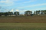
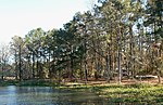
The Chattahoochee River () forms the southern half of the Alabama and Georgia border, as well as a portion of the Florida and Georgia border. It is a tributary of the Apalachicola River, a relatively short river formed by the confluence of the Chattahoochee and Flint rivers and emptying from Florida into Apalachicola Bay in the Gulf of Mexico. The Chattahoochee River is about 430 miles (690 km) long. The Chattahoochee, Flint, and Apalachicola rivers together make up the Apalachicola–Chattahoochee–Flint River Basin (ACF River Basin). The Chattahoochee makes up the largest part of the ACF's drainage basin.
Excerpt from the Wikipedia article Chattahoochee River (License: CC BY-SA 3.0, Authors, Images).Chattahoochee River
North River Landing Road,
Geographical coordinates (GPS) Address Nearby Places Show on map
 Continue reading on Wikipedia
 Geographical coordinates (GPS)
| Latitude | Longitude |
|---|---|
| N 30.708888888889 ° | E -84.863888888889 ° |
Address
North River Landing Road
32324
Florida, United States
Open on Google Maps