Sha Tin District

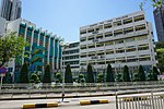
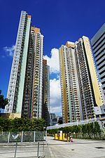
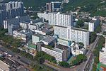
Sha Tin District is one of the 18 districts of Hong Kong. As one of the 9 districts located in the New Territories, it covers the areas of Sha Tin, Tai Wai, Ma On Shan, Fo Tan, Siu Lek Yuen, Kwun Yam Shan and Ma Liu Shui. The district is the most populous district in Hong Kong, with a population of 659,794 as per 2016 by-census, having a larger population than many states or dependencies including Iceland, Malta, Montenegro and Brunei.The Sha Tin District covers approximately 69.4 km2 (26.8 sq. mi), including Sha Tin New Town and several country parks. Built mostly on reclaimed land in Sha Tin Hoi, the well-developed Sha Tin New Town comprises mainly residential areas along the banks of the Shing Mun River Channel. In the early 1970s it was a rural township of about 30,000 people. After Sha Tin's first public housing estate, Lek Yuen Estate, was completed in 1976, the settlement began to expand. Today, about 65% of the district's population live in public rental housing, housing under Hong Kong's Tenants Purchase Scheme, or Home Ownership Scheme.
Excerpt from the Wikipedia article Sha Tin District (License: CC BY-SA 3.0, Authors, Images).Sha Tin District
Tak Hau Street, Sha Tin District
Geographical coordinates (GPS) Address Nearby Places Show on map
 Continue reading on Wikipedia
 Geographical coordinates (GPS)
| Latitude | Longitude |
|---|---|
| N 22.38715 ° | E 114.19534 ° |
Address
禾輋廣場 Wo Che Plaza
Tak Hau Street 3
Sha Tin District
Hong Kong, China
Open on Google Maps