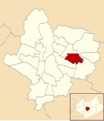
Evington Valley
Areas of LeicesterLeicesterLeicestershire geography stubsUse British English from October 2019
Evington Valley is an area in Leicester, England. It is roughly bounded by East Park Road to the west (west of which is Highfields), Chesterfield/Ethel Road to the north (north of which is North Evington), Wakerly Road to the east (east of which is Evington village) and to the south borders Stoneygate. The population of the area falls within the Evington ward of Leicester City Council.
Excerpt from the Wikipedia article Evington Valley (License: CC BY-SA 3.0, Authors).Evington Valley
Stoughton Drive North, Leicester Stoneygate
Geographical coordinates (GPS) Address Nearby Places Show on map
Geographical coordinates (GPS)
| Latitude | Longitude |
|---|---|
| N 52.623 ° | E -1.102 ° |
Address
Stoughton Drive North
Stoughton Drive North
LE5 5TR Leicester, Stoneygate
England, United Kingdom
Open on Google Maps


