place

West Strand Historic District

Historic districts in Ulster County, New YorkHistoric districts on the National Register of Historic Places in New York (state)NRHP infobox with nocatNational Register of Historic Places in Ulster County, New YorkUlster County, New York Registered Historic Place stubs
Use mdy dates from August 2023
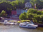
West Strand Historic District Nov 08

West Strand Historic District is a national historic district located at Kingston in Ulster County, New York. The district includes nine contributing buildings. It comprises a grouping of 19th century commercial buildings. They are four story buildings generally constructed of brick with storefronts on the first floor.It was listed on the National Register of Historic Places in 1974. It is located adjacent to the Rondout-West Strand Historic District, listed on the National Register of Historic Places in 1979.

Excerpt from the Wikipedia article West Strand Historic District (License: CC BY-SA 3.0, Authors, Images).

West Strand Historic District
West Strand Street,

Geographical coordinates (GPS) Address Nearby Places
placeShow on map

Wikipedia: West Strand Historic DistrictContinue reading on Wikipedia

Geographical coordinates (GPS)

Latitude Longitude
N 41.917777777778 ° E -73.983611111111 °
placeShow on map

Address

West Strand Street 29
12401
New York, United States
mapOpen on Google Maps

West Strand Historic District Nov 08
Share experience

Nearby Places

Kingston–Port Ewen Suspension Bridge

The Kingston–Port Ewen Suspension Bridge, sometimes known as the "Rondout Creek bridge", "Old Bridge" or "Wurts Street Bridge", is a steel suspension bridge spanning Rondout Creek, near where it empties into the Hudson River. It connects the City of Kingston to the north, with the village of Port Ewen to the south. Completed in 1921, it was the final link in New York's first north-south highway on the West Shore of the Hudson, and is considered an important engineering accomplishment associated with the development of early motoring. Construction began in 1916, with a view to replacing the Rondout Creek chain ferry named Skillypot, known for sporadic service. The Skillypot was named after a derivative of a Dutch word for tortoise, schildpad. The bridge was designed by the firms of Holton D. Robinson and John A. Roebling's Sons Company, with Holton D. Robinson, Daniel E. Moran, William Yates listed as chief engineers Construction was hampered by local political and financial difficulties, as well as material shortages caused by entry by the United States into World War I, and was suspended until 1920. When construction resumed, David B. Steinman was among the engineering staff, acting as Assistant Engineer. Completion took about a year, and local legend has it that the contractors employed a woman as a welder: commonplace during World War II, but unheard of in 1920. Ten thousand people attended the bridge's dedication on November 2, 1921. The bridge has a very hilly approach on the north side and crosses a small island in the creek. It forms a dramatic backdrop to the Rondout-West Strand Historic District to the east. The bridge was closed on September 25, 2020, for a three-year reconstruction project that is estimated to cost $44.6 million.

Rondout–West Strand Historic District

The Rondout–West Strand Historic District is located on the shore of Rondout Creek along the southern boundary of the city of Kingston, New York, United States. Formerly Rondout, New York, it is bounded by the creek, Broadway, Hone, Ravine and McEntee streets, an area of 570 acres (2.3 km²) containing 259 buildings, most dating to the 19th century. US 9W and the John T. Loughran Bridge are immediately to the east; the Kingston-Port Ewen Suspension Bridge crosses the creek to the west. The neighborhood is often referred to locally by either of the two names. The name of the Rondout Creek comes from the fort, or redoubt, that was erected near its mouth The Dutch equivalent of the English word redoubt (meaning a fort or stronghold), is reduyt. In the Dutch records of Wildwyck, however, the spelling used to designate this same fort is invariably Ronduyt during the earliest period, with the present form rondout (often capitalized) appearing as early as November 22, 1666. Because the spelling of the word was unusual and implied a proper name, the translators, Oppenheim and Versteeg, preserved the original form in their translations instead of giving the English equivalent, as O´Callaghan and Fernow had done. The Dutch word ronduyt is an adjective meaning "frankly" or "positively." The word could also be broken down into its components and translated, literally, "round-out." However, it seems unlikely that the inhabitants of Esopus had any special meaning in mind when they corrupted the Dutch word reduyt into ronduyt and rondout. Most likely, this corrupting process merely represented the simplification of a word (reduyt). The Strand (original pronunciation, in Dutch: "strunt"). Strand means, in Dutch, a shore or beach. The street running along the north shore of the Rondout Creek near its mouth has always been called "The Strand," or, more recently, "Strand Street" (East and West).A short, easily navigable distance up the creek from the Hudson River, the area, originally known as Kingston Landing, had always been an ideal location for a harbor. But it was not until the establishment of the Delaware and Hudson Canal in 1828 made it a key junction for coal being shipped from Northeast Pennsylvania and bluestone being quarried from the nearby Catskill Mountains that it was able to fully take advantage of that situation. Rondout was the eastern terminus of the Rondout and Oswego Railroad (later absorbed into the Ulster and Delaware Railroad), built in the latter 1860s, which took rail cars straight to Rondout Creek. It grew so rapidly that it incorporated as the Village of Rondout in 1849. By 1872 it grew so much more it merged with the then-Town of Kingston to form today's city. By the time the canal closed in 1899, it had acquired buildings in all 19th-century architectural styles.The industrial base established was such that the neighborhood remained prosperous long after the closing of the canal. But by the 1960s it had, like similar areas in many other American cities, fallen into decay, and it was only when urban renewal and the construction of the bridge led to the demolition of part of the neighborhood that efforts to preserve the remainder were seriously undertaken.It was added to the National Register of Historic Places in 1979; the city has recognized it in its ordinances as well. Today, the area is still an active waterfront, although it primarily sees recreational traffic. Many small boutiques and restaurants have opened in the old buildings along the streets; it has become a popular destination for visitors both by land and water. It is located adjacent to the West Strand Historic District, listed on the National Register of Historic Places in 1974.

Hudson River Maritime Museum

The Hudson River Maritime Museum is a maritime museum dedicated to the Hudson River. It is located at 50 Rondout Landing at the foot of Broadway in Kingston, New York, United States, along Rondout Creek in the city's old waterfront, just east of the John T. Loughran Bridge. The acronym HRMM is often used to refer the Hudson River Maritime Museum in publications. Its collections are devoted to the history of shipping, boating and industry on the Hudson and its tributaries, such as the Rondout, where Kingston grew prosperous early in the 19th century as the northern end of the Delaware and Hudson Canal. The city was the busiest port between New York City and Albany. The museum was founded in 1980 by local Hudson River enthusiasts, but did not move to its present property, an old boat shop, until 1983. Its exhibits include various small craft, artifacts of river steamships such as the Mary Powell, a research library, ice-harvesting tools and maps, paintings and sketches from past eras. The 1898 steam tugboat Mathilda is displayed in the yard next to the museum. In the summer months boat trips are available to nearby Rondout Lighthouse, where the creek drains into the Hudson. Boats putting in at the dock range from privately owned pleasure craft to oceangoing cruise liners. The Hudson River Sloop Clearwater has its winter home port here and visits frequently as do many historic reproduction vessels such as the Onrust and the Half Moon. As well as having the ability to accommodate deep draft vessels at their docks the museum provides free docking for canoes and kayaks. The Hudson River Maritime Museum is home to the Kingston High School Crew Team, the Rondout Rowing Club and the Kingston Sailing Club. The museum is a membership supported organization and sponsors festivals and events including the Antique and Classic Boat Society Boat Show, Hudson River Days with music, crafts and displays, the "Follow the River" Lecture Series, Cinema Sundays and Family Days. HRMM opened the Wooden Boat School in 2016 and the Sailing & Rowing School in 2017. Classes are offered year-round at the Wooden Boat School, and the Sailing & Rowing School limit their offerings to Spring, Summer, and Fall. It is open 11 am - 5 pm, Thursday - Sunday during winter, and 11 am - 5 pm, Monday - Sunday during summer. Admission cost US$9 for adults and US$6 for children and seniors, US$25 family rates available (restrictions apply). Special tours for groups are available. There is a gift shop which features books pertaining to Kingston and the Hudson Valley as well as the maritime history of the Hudson.

Chestnut Street Historic District (Kingston, New York)

Chestnut Street Historic District is a national historic district located at Kingston in Ulster County, New York. The district includes 44 contributing buildings and six contributing structures. It comprises a collection of substantial 19th and early 20th century residences on dramatic hillside sites. It also includes the Immanuel Lutheran Church and Bruck Funeral Home.It was listed on the National Register of Historic Places in 1985. Lowell Things' book "The Street That Built The City" goes into great depth about Chestnut St. The street that built it or much of it is on a quiet hilltop overlooking the Hudson River a hundred miles north of New York s harbor. Chestnut Street s first resident was an engineer who helped build the Delaware and Hudson Canal, which brought millions of tons of coal from Pennsylvania to the port at Rondout to be hauled down the Hudson River on barges pulled by steamboats belonging to another Chestnut Street resident to fuel a rapidly growing New York City. Seven owners of brickyards lived on the street, and their hundreds of millions of bricks rose skyward in New York while bluestone slabs shipped from nearby Wilbur paved the city s sidewalks. The owner of the steamboat company that pushed or pulled the coal, bricks, cement and bluestone built the grandest house on the street and one of the largest mansions in the Hudson Valley, which was built almost exactly where once stood the studio of his friend, a famous painter whose close circle included one of the greatest American architects of his time and the greatest actor of his time, as well as Frederic Church, Worthington Whittredge, Sanford Gifford and other legendary artists of the Hudson River School. But The Street That Built a City is more than just a tale of city-building and rich and famous people. It is also the tale of the Irish and German immigrants and others who worked on the boats and the docks and in the brickyards, who taught school, tended shops, and doctored the sick, and whose children played in abandoned mansions and Indian caves. It is a carefully researched community history but of a community barely four blocks long. The houses they built, their occupations, the transportation they used, how they lived and played down through the generations, is all documented in detail. When Chestnut Street s first resident, James McEntee, moved to the Kingston area in 1828 to begin working as an engineer on the Delaware and Hudson Canal, the village of Rondout consisted of 5 families and a sleepy river landing. By the time McEntee died in 1887, Rondout had become a densely settled community of buildings dwellings, grocery stores (46 in all), boat repair sheds, dock buildings, bars, churches and had joined with the Village of Kingston to become the City of Kingston. Today the street that built a city is part of the Chestnut Street Historic District in Kingston, New York. Much of the former Rondout Village that Chestnut Street looked out upon from its hilltop is gone today 427 Rondout buildings were torn down between 1966 and 1970 during the misguided Urban Renewal program and even Chestnut Street s greatest mansion is also gone, but others remain, and the street s 19th-century architectural splendor is largely intact