place

Kiveton Bridge railway station
DfT Category F2 stationsFormer London and North Eastern Railway stationsNorthern franchise railway stationsRailway stations in Great Britain opened in 1929Railway stations in Rotherham
Use British English from January 2017Yorkshire and the Humber railway station stubs
Kiveton Bridge railway station

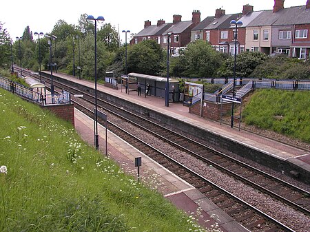
Kiveton Bridge railway station serves the village of Kiveton Park in South Yorkshire, England. It also served the now closed Kiveton Park Colliery which was adjacent. The station was opened by the London and North Eastern Railway on 8 July 1929 following pressure from the local councils who considered Kiveton Park station and Waleswood station too far away from the centre of the community. The new station consisted of two flanking wooden platform linked by an overbridge, access to which was gained through the booking office, set at road level adjacent to the main road through, and linking the villages. The station was originally served by stopping services linking Sheffield Victoria, Cleethorpes and Lincoln Central. In the 1950s the wooden platforms were replaced with concrete ones and the wooden station buildings by plain brick built structures. Along with neighbouring Kiveton Park station it was completely rebuilt during the early-1990s with modern platforms, lighting and waiting shelters, this work being funded by the South Yorkshire Passenger Transport Executive. On completion of the work the station received new signs with the name erroneously shown as "Kiverton Bridge". These were replaced with the correct spelling by 21 May 1993. This was not the first time the name had been incorrectly shown: British Railways made the same mistake on large enamel signs in the late 1950s.

Excerpt from the Wikipedia article Kiveton Bridge railway station (License: CC BY-SA 3.0, Authors, Images).

Kiveton Bridge railway station
Colliery Road,

Geographical coordinates (GPS) Address Nearby Places
placeShow on map

Wikipedia: Kiveton Bridge railway stationContinue reading on Wikipedia

Geographical coordinates (GPS)

Latitude Longitude
N 53.34046 ° E -1.26575 °
placeShow on map

Address

Colliery Road

Colliery Road
S26 6QX , Wales
England, United Kingdom
mapOpen on Google Maps

Kiveton Bridge railway station
Share experience

Nearby Places

Todwick
Todwick

Todwick is a village in the Metropolitan Borough of Rotherham in South Yorkshire, England. It has a population of 1,637, reducing marginally to 1,634 at the 2011 Census, and contains a primary school (junior and infants) and a nursery, Todwick Early Years. Todwick also is home to a pub, The Red Lion, and a church. There is a village hall adjacent to the primary school, and this is on the corner of Kiveton Lane and The Pastures. The Pastures has the only shops in the village on it; Cyprus Gardens pizza house and Heaven Is Homemade Vintage Tea Room. The main street in Todwick is Kiveton Lane, which runs through the heart of the village, connecting it at one end to the A57, towards Dinnington, Anston, Thurcroft etc., and at the other end to Station Road in Kiveton Park. At the Kiveton Park end of Kiveton Lane there is a small marker, which was reputed to be the site of a look out post for Robin Hood. A plaque marks the spot behind a white gate just outside the village. Todwick can only be accessed by road or footpath; the nearest railway stations are Kiveton Bridge and Kiveton Park on the Sheffield to Lincoln line. Its location near to the M1 motorway gives the village's inhabitants good access to the country. Local towns provide many job opportunities for Todwick's working population. Todwick has two parks; the smallest is alongside the church graveyard on Lindleys Croft, and has had in previous years, swings, a roundabout, climbing frame and a basketball court. The other park is known as "the rec" to locals. It has two football fields on it, as well as slides and roundabouts at the village end, and a bowling green and cricket field at the far end. The village's annual bonfire on Guy Fawkes Night is held here, where many locals gather for hot dogs, toffee apples, sparklers and fireworks, although this has not been organised for the past few years due to health and safety hazards. Todwick Junior and Infant School was rated as satisfactory in an Ofsted report during 2010.In the 1960s, plans were made for an airport at Todwick to serve Sheffield and Rotherham. However, the plans were not realised, and Sheffield did not get its own airport until the 1990s, which itself closed fully in 2008.

Harthill, South Yorkshire

Harthill is a village in the Metropolitan Borough of Rotherham (part of South Yorkshire, England), on the border with Derbyshire. It lies between Killamarsh and Thorpe Salvin, and is located at approximately 53°19′10″N 1°15′30″W, at an elevation of around 110 metres above sea level. In the 2001 census, the civil parish of Harthill with Woodall had a population of 1,909, reducing slightly to 1,879 at the 2011 Census.Harthill is traditionally an agricultural village, although there is also a history of quarrying whetstones for use in knife-sharpening. The parish church of All Hallows dates from 1085, when it was commissioned by William de Warenne. The tower is 14th century. The Dukes of Leeds, major landowners in the area, and their families, are interred in the crypt. Harthill has two public houses: the Beehive and the Blue Bell. Harthill is the principal village in the civil parish of Harthill with Woodall. The parish also contains Harthill Reservoir, which feeds the Chesterfield Canal, Nor Wood, and the hamlet of Woodall with its M1 motorway service station. The reservoir was constructed in 1796 and in 2020 the Canals and Rivers Trust announced a £5 million programme of works to upgrade the overflow spillway of the earth dam. The reservoir provides leisure facilities for Rotherham Sailing Club, Yorkshire Outdoor Swimmers and fishing. The village is served by several public transport routes. First South Yorkshire operate the hourly service X54 to Sheffield from Monday to Saturday, with TM Travel operating it on Sundays. First also run service 29 to Rotherham between Monday and Saturday, with TM Travel operating service 29a on evenings and Sundays. Stagecoach also operate the circular route 26/26a during Monday to Saturday daytime, connecting Harthill with Crystal Peaks. There is also a 1-a-day service to the Hallamshire Hospital in the form of service X30; this is run by TM Travel, Monday to Saturday at 7 am.