place

Catawissa Friends Meetinghouse

1789 establishments in Pennsylvania18th-century Quaker meeting housesChurches completed in 1789Churches in Columbia County, PennsylvaniaChurches on the National Register of Historic Places in Pennsylvania
Historic American Buildings Survey in PennsylvaniaNational Register of Historic Places in Columbia County, PennsylvaniaQuaker meeting houses in Pennsylvania
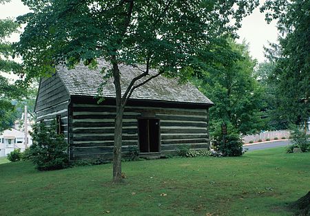
Catawissa Friends Meetinghouse

Catawissa Friends Meetinghouse is a historic Quaker meetinghouse at South and 3rd Streets in Catawissa, Columbia County, Pennsylvania. It was built about 1789, and is a one-story log building on a stone foundation. It measures 30 feet (9.1 m) by 27 feet 6 inches (8.38 m).It was added to the National Register of Historic Places in 1978.

Excerpt from the Wikipedia article Catawissa Friends Meetinghouse (License: CC BY-SA 3.0, Authors, Images).

Catawissa Friends Meetinghouse
North 3rd Street,

Geographical coordinates (GPS) Address Website Nearby Places
placeShow on map

Wikipedia: Catawissa Friends MeetinghouseContinue reading on Wikipedia

Geographical coordinates (GPS)

Latitude Longitude
N 40.953333333333 ° E -76.461388888889 °
placeShow on map

Address

Catawissa Police Station

North 3rd Street 118

Pennsylvania, United States
mapOpen on Google Maps

Website
catawissa.us

linkVisit website

Catawissa Friends Meetinghouse
Share experience

Nearby Places

Catawissa Creek
Catawissa Creek

Catawissa Creek (colloquially known as The Cat) is a 41.8-mile-long (67.3 km) tributary of the Susquehanna River in east-central Pennsylvania in the United States. Its watershed has an area of 153 square miles (400 km2).The waters of Catawissa Creek are highly acidic, with a pH of 4.5, due to runoff from an abandoned mine in the creek's watershed. Catawissa Creek is smaller than the nearby Fishing Creek due to a lack of major tributaries.Catawissa Creek starts in Luzerne County, not far from Hazleton. It flows west and slightly south into Schuylkill County before flowing north into Columbia County and then west to the Susquehanna River, which it flows into at Catawissa. It parallels Catawissa Mountain for a significant portion of its course. The surface rock in Catawissa Creek largely consists of sedimentary rock, such as sandstone and shale. However, there is also coal in the watershed. Major soils in the creek's watershed include the Leck Kill soil and the Albrights series. Most of the steeper hills in the watershed are situated near the headwaters of the creek. Coal mining was once a major industry in the Catawissa Creek watershed, but this is no longer the case. Major tributaries of Catawissa Creek include Little Catawissa Creek and Tomhicken Creek. The president of the Catawissa Creek Watershed Restoration Association, Ed Wytovich, called Catawissa Creek "probably the most beautiful screwed-up stream east of the Mississippi".

Fishing Creek (North Branch Susquehanna River tributary)

Fishing Creek is a 29.98-mile (48.25 km) long tributary of the Susquehanna River in Columbia County, Pennsylvania, in the United States. It joins the Susquehanna River near the census-designated place of Rupert and the town of Bloomsburg. The watershed has an area of 385 square miles (1,000 km2). Nomadic Native Americans arrived in the lower reaches of Fishing Creek around 8000 BCE, and some were spending winters in the upper reaches of the valley by 3000 to 2000 BCE. In the past few centuries, the Fishing Creek area has been home to many industries, mills, and dams. It drains parts of five Pennsylvania counties: Columbia, Montour, Sullivan, Luzerne, and Lycoming. The creek's main tributaries include Hemlock Creek, Little Fishing Creek, Green Creek, Huntington Creek, West Branch Fishing Creek, and East Branch Fishing Creek. Public recreation activities include canoeing, birdwatching, and fishing. The creek is known for its trout population, which includes brook, brown and rainbow trout; it also contains many other species of fish. Northern hardwood trees and ruffed grouse live in the surrounding area. Some stretches of Fishing Creek contain significant amounts of algae because of leaking septic systems in the watershed. The area around the tributary West Creek is the least habitable part of the Fishing Creek area, according to a 2011 study. The water quality of Fishing Creek can vary. Its pH ranges from 4.9 to 8.5, while the concentration of dissolved oxygen ranges from 5 to 17.5 mg per liter. The creek's average discharge is 615 cubic feet per second (17.4 m3/s); its watershed contains gravel, shale and various loams—in particular the Albrights soil series and the Leck Kill soil.