place

Egg Rock

19th-century inscriptionsConcord, MassachusettsHistory of MassachusettsIslands of Middlesex County, MassachusettsLandmarks in Massachusetts
River islands of MassachusettsTourist attractions in Concord, Massachusetts
Egg Rock 1904
Egg Rock 1904

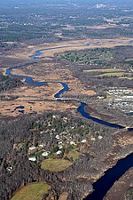
Egg Rock is an outcrop of Silurian Straw Hollow Diorite at the confluence of the Assabet and Sudbury rivers, where they form the Concord River in Concord, Massachusetts. The outcrop is located on a roughly oval intermittent island of about 100 by 50 meters. Egg Rock is usually accessible using foot trails over land, but during high river levels the island is separated from the mainland by a narrow channel. The highest point of Egg Rock is about 39 meters above mean sea level and about 6 meters above normal river level. The United States Geological Survey (USGS) Geographic Names Information System (GNIS) includes Egg Rock as GNIS feature 617309, classified as an island. In the GNIS database as of February 2010, the listed position (latitude 42.4645383, longitude -71.3592266) is misplaced by about 125 meters to the southwest, and is not actually located on the intermittent island. A more correct position is latitude 42.4651, longitude -71.3585.

Excerpt from the Wikipedia article Egg Rock (License: CC BY-SA 3.0, Authors, Images).

Egg Rock
Calf Pasture Trail (yellow dot),

Geographical coordinates (GPS) Address Nearby Places
placeShow on map

Wikipedia: Egg RockContinue reading on Wikipedia

Geographical coordinates (GPS)

Latitude Longitude
N 42.4651 ° E -71.3585 °
placeShow on map

Address

Egg Rock Land

Calf Pasture Trail (yellow dot)
01742
Massachusetts, United States
mapOpen on Google Maps

Egg Rock 1904
Egg Rock 1904
Share experience

Nearby Places

Sudbury River
Sudbury River

The Sudbury River is a 32.7-mile-long (52.6 km) tributary of the Concord River in Middlesex County, Massachusetts, in the United States.Originating in the Cedar Swamp in Westborough, Massachusetts, near the boundary with Hopkinton, the Sudbury River meanders generally northeast, through Fairhaven Bay, and to its confluence with the Assabet River at Egg Rock in Concord, Massachusetts, to form the Concord River. It has a 162-square-mile (420 km2) drainage area. A 1775 map identifies the river by this name as passing through the town of Sudbury, itself established 1639. On April 9, 1999, nearly 17 miles (27 km) of the river were "recognized for their outstanding ecology, history, scenery, recreation values, and place in American literature," by being designated as a part of the National Wild and Scenic Rivers System. The 14.9-mile (24.0 km) segment of the Sudbury River beginning at the Danforth Street Bridge in the city of Framingham, downstream to the Route 2 bridge in Concord, is designated as a Scenic River, and the 1.7-mile (2.7 km) segment from the Route 2 bridge downstream to its confluence with the Assabet River at Egg Rock is designated as a Recreational River, along with adjoining stretches of the Assabet and Concord rivers.Mercury contamination was discovered in the 1970s from the Nyanza plant in Ashland. The EPA subsequently listed the town as a toxic site and led a cleanup effort to repair the damage. It is still recommended that fish caught downriver not be eaten.

Concord, Massachusetts

Concord () is a town in Middlesex County, Massachusetts, in the United States. In the 2020 census, the town population was 18,491. The United States Census Bureau considers Concord part of Greater Boston. The town center is near where the confluence of the Sudbury and Assabet rivers forms the Concord River. The area that became the town of Concord was originally known as Musketaquid, an Algonquian word for "grassy plain." Concord was established in 1635 by a group of English settlers; by 1775, the population had grown to 1,400. As dissension between colonists in North America and the British crown intensified, 700 troops were sent to confiscate militia ordnance stored at Concord on April 19, 1775. The ensuing conflict, the battles of Lexington and Concord, were the incidents (including the shot heard round the world) that triggered the American Revolutionary War. A rich literary community developed in Concord during the mid-19th century, centered around Ralph Waldo Emerson. Emerson's circle included Nathaniel Hawthorne, Louisa May Alcott and Henry David Thoreau. Major works written in Concord during this period include Alcott's novel Little Women, Emerson's essay Self-Reliance, and Thoreau's Walden and Civil Disobedience. In this era, the now-ubiquitous Concord grape was developed in Concord by Ephraim Wales Bull. In the 20th century, Concord developed into an affluent Boston suburb and tourist destination, drawing visitors to the Old North Bridge, Orchard House and Walden Pond. The town retains its literary culture and is home to notable authors, including Doris Kearns Goodwin, Alan Lightman and Gregory Maguire. Concord is also notable for its progressive and environmentalist politics, becoming in 2012 the first community in the United States to ban single-serving PET bottles.

Concord Armory
Concord Armory

The Concord Armory is an historic former armory at 51 Walden Street in Concord, Massachusetts. It now serves as the Performing Arts Center at 51 Walden, which is operated by the Friends of Performing Arts in Concord (FOPAC). Resident groups include The Concord Players, The Concord Band, and The Concord Orchestra. The armory was built in 1887 and added to the National Register of Historic Places in 2007, as a rare well-preserved example of a wood-frame municipal armory.The armory was built in several stages, between 1887 and 1927. The front portion, or headhouse, was built in 1887, and the drill shed added in 1888. In 1896 the drill shed was lengthened. When the building was converted for use by veterans organizations and the Concord Players in the 1920s, the area housing the stage was added, to a design drawn up by the noted theater architect Clarence Blackall. In 1927 the stage area was extended to the rear to provide additional space for scenery. The building interior was extensively altered in the 1970s when FOPAC took over the property.The lower level of the head house now serves as a lobby area, which also extends into the former drill shed; its upper level serves as a dance studio. The drill shed has been converted into a theatrical auditorium, with its original ceiling trusses exposed, and acoustic treatments on the walls. The basement houses storage space and dressing rooms.Historical uses of the building during the 20th century include the screening of films by the Red Cross in the 1920s, and for annual town meetings between 1933 and 1946. It was also used to house town offices, and to provide space for a youth center. Due to its deteriorating condition, the building was several times considered for demolition in the 1950s and 1960s, but public outcry was successful in preventing that fate. FOPAC was formed in 1972 to convert the building into a dedicated performing arts space.