place

Mount Taylor (Australian Capital Territory)
Mountains of the Australian Capital TerritoryParks in CanberraSilurian volcanismUse Australian English from February 2018Volcanoes of the Australian Capital Territory
MtTaylorWodenValley
MtTaylorWodenValley

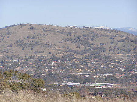
Mount Taylor is a prominent hill with an elevation of 856 metres (2,808 ft) AHD  that is located between the Woden Valley, Weston Creek district and Tuggeranong Valley, in Canberra, within the Australian Capital Territory, Australia. Mount Taylor is part of the Canberra Nature Park and is surrounded by the suburbs of Kambah, Fisher, Waramanga, Chifley, Pearce, and Torrens. There are walking tracks to the peak. While there is no public road access to the peak there is a fire trail up the mountain from the end of Waldock St, Chifley where there is also a car park and picnic tables. The fire trail (also known as the management trail) is normally closed to public vehicular access by locked gates, but the gates contain access points for walkers. The trail is especially popular with families and older walkers as it provides the easiest and most leisurely access to the peak. Originally a dirt road, it was partially sealed in 2009 on the steeper grades to make it safer for walkers and mountain bike riders.

Excerpt from the Wikipedia article Mount Taylor (Australian Capital Territory) (License: CC BY-SA 3.0, Authors, Images).

Mount Taylor (Australian Capital Territory)
Summit Fire Trail,

Geographical coordinates (GPS) Address Nearby Places
placeShow on map

Wikipedia: Mount Taylor (Australian Capital Territory)Continue reading on Wikipedia

Geographical coordinates (GPS)

Latitude Longitude
N -35.371944444444 ° E 149.07277777778 °
placeShow on map

Address

Summit Fire Trail

Summit Fire Trail
2902
Australia
mapOpen on Google Maps

MtTaylorWodenValley
MtTaylorWodenValley
Share experience

Nearby Places

Phillip, Australian Capital Territory

Phillip (postcode: 2606) is a suburb of Canberra, Australia in the district of Woden Valley. It is located in the centre of the district and contains the district's main commercial centre, Woden Town Centre. Phillip had a residential population of 5,197 at the 2021 census. 67.0% of the population lived in flats. Many more flats are being planned or built. The suburb is named after Arthur Phillip, the first Governor of New South Wales. The suburb name was gazetted on 12 May 1966. Streets in Phillip use names associated with the First, Second and Third Fleets; streets in the Swinger Hill were named after architects.As the commercial and geographical centre of Woden, Phillip contains many of the district's key facilities. As well as the Woden Town Centre, which includes the Westfield Woden shopping centre, a bus interchange and the Lovett Tower (the tallest commercial office building in Canberra), it has its own commercial area located along Botany, Townshend and Parramatta Streets. Eddison Park, including Woden Skate Park and Disc Golf Course, and the Woden Cemetery are located in the suburb. Phillip also contains a number of sporting facilities, including the Phillip Enclosed Oval, which has been known as Football Park since 1981 and was the headquarters of Australian rules football in Canberra during the 1980s and 1990s, and the Phillip Swimming & Ice Skating Centre, home to the CBR Brave of the Australian Ice Hockey League. The Canberra College is situated in Phillip.