Richborough Castle

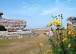
Richborough Castle is a Roman Saxon Shore fort better known as Richborough Roman Fort. It is situated in Richborough near Sandwich, Kent. Substantial remains of the massive fort walls still stand to a height of several metres. It is part of a larger Roman town called Rutupiae or Portus Ritupis that developed around the fort and the associated port. The settlement was founded after Roman conquest of Britain of Britain in AD 43. Because of its position near to a large natural harbour in the Wantsum Channel and to the mouth of the Stour, Rutupiae served as a main gateway to Roman Britain and the starting point for the road now known as Watling Street. The site is now two and half miles inland from the current coastline. Earth fortifications were first dug on the site in the 1st century, probably for a storage depot and bridgehead for the Roman army. The site expanded into a major civilian and commercial town, and the stone Saxon Shore fort was added around the year 277. The later fort is believed to have been constructed by the rebel Carausius. The site is now under the care of English Heritage.
Excerpt from the Wikipedia article Richborough Castle (License: CC BY-SA 3.0, Authors, Images).Richborough Castle
Richborough Road,
Geographical coordinates (GPS) Address Website External links Nearby Places Show on map
Geographical coordinates (GPS)
| Latitude | Longitude |
|---|---|
| N 51.294 ° | E 1.332 ° |
Address
Richborough Fort (Richborough Castle)
Richborough Road
CT13 9JQ
England, United Kingdom
Open on Google Maps


