Acton Turville

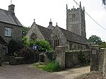
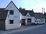
Acton Turville is a parish in the Cotswold Edge ward within South Gloucestershire, England. It lies 17 miles (27 km) east-northeast of Bristol and 93 miles (150 km) due west of London, with the M4 south of the parish. Acton Turville consists of a cluster of households across 1,009 acres, with a total population of 370 people. Acton Turville is also listed as "Achetone" in the Domesday Book.According to John Marius in 1870, From the imperial gazetteer of England and Wales - Acton Turville is: "a parish in Chipping Sodbury district, Gloucester; near the Fosse way and under the Cotswold Hills. It lies 5.5 miles east of Chipping Sodbury, and 7.5 miles east of Yate railway station".
Excerpt from the Wikipedia article Acton Turville (License: CC BY-SA 3.0, Authors, Images).Acton Turville
Littleton Drew Road,
Geographical coordinates (GPS) Address Nearby Places Show on map
Geographical coordinates (GPS)
| Latitude | Longitude |
|---|---|
| N 51.526 ° | E -2.276 ° |
Address
Littleton Drew Road
Littleton Drew Road
GL9 1HH
England, United Kingdom
Open on Google Maps


