Rigolets
Bodies of water of LouisianaBodies of water of Orleans Parish, LouisianaBodies of water of St. Tammany Parish, LouisianaStraits of the CaribbeanStraits of the United States

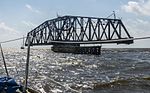
Rigolets is a 12.9-kilometre-long (8.0 mi) deepwater strait in Louisiana. "Rigolets" comes from the word rigole, French for 'trench' or 'gutter'. The name is now locally pronounced "RIG-uh-leez". The strait begins at 30°10′40″N 89°44′40″W and follows a generally eastward course to Lake Borgne, a lagoon in the Gulf of Mexico, and finally to the Gulf of Mexico, where it ends at 30°09′16″N 89°37′31″W. Along with nearby Chef Menteur Pass, the Rigolets connects Lake Pontchartrain and Lake St. Catherine in Louisiana to Lake Borgne, and then to the Gulf of Mexico. It forms the boundary between New Orleans (Orleans Parish) and St. Tammany Parish.
Excerpt from the Wikipedia article Rigolets (License: CC BY-SA 3.0, Authors, Images).Rigolets
Geographical coordinates (GPS) Address Nearby Places Show on map
 Continue reading on Wikipedia
 Geographical coordinates (GPS)
| Latitude | Longitude |
|---|---|
| N 30.154444 ° | E -89.625278 ° |
Address
St. Tammany Parish
Louisiana, United States
Open on Google Maps