place

Brighton Heights Reformed Church

1823 establishments in New York (state)19th-century Reformed Church in America church buildingsBuilding fires in New York CityBurned religious buildings and structures in the United StatesChurches completed in 1863
Churches completed in 1866Churches in Staten IslandFormer Dutch Reformed churches in New York (state)Gothic Revival church buildings in New York (state)New York City Designated Landmarks in Staten IslandNew York City Registered Historic Place stubsNew York City church stubsProperties of religious function on the National Register of Historic Places in Staten IslandReligious buildings and structures firesSt. George, Staten IslandStaten Island building and structure stubsStaten Island geography stubs
Brighton Heights Reformed Ch SI jeh

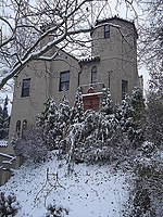
Brighton Heights Reformed Church is a Dutch Reformed church at 320 St. Marks Place in St. George, Staten Island, New York City. It is the second of two church buildings that have stood on the site. The AIA Guide to New York City (1978) states that the original church was built in 1866, although the construction for the previous location began in 1818, and became independent in 1823, with one of its founding members being Vice President Daniel D. Tompkins.The original building was added to the National Register of Historic Places in 1982. The current structure is not the one added to the NRHP. The original structure was destroyed in an accidental fire in the 1990s.

Excerpt from the Wikipedia article Brighton Heights Reformed Church (License: CC BY-SA 3.0, Authors, Images).

Brighton Heights Reformed Church
Montgomery Avenue, New York Staten Island

Geographical coordinates (GPS) Address Nearby Places
placeShow on map

Wikipedia: Brighton Heights Reformed ChurchContinue reading on Wikipedia

Geographical coordinates (GPS)

Latitude Longitude
N 40.641388888889 ° E -74.078611111111 °
placeShow on map

Address

Montgomery Avenue 26
10301 New York, Staten Island
New York, United States
mapOpen on Google Maps

Brighton Heights Reformed Ch SI jeh
Share experience

Nearby Places

St. George, Staten Island

St. George is a neighborhood on the northeastern tip of Staten Island in New York City, along the waterfront where the Kill Van Kull enters Upper New York Bay. It is the most densely developed neighborhood on Staten Island, and the location of the administrative center for the borough and for the coterminous Richmond County. The St. George Terminal, serving the Staten Island Ferry and the Staten Island Railway, is also located here. St. George is bordered on the south by the neighborhood of Tompkinsville and on the west by the neighborhood of New Brighton. What is now St. George was initially occupied by the Lenape Native Americans, then colonized by the Dutch and the British. The first residential developments arose in the 1830s, and through the late 19th century, the area was a summer resort. Until the construction of the ferry–railroad terminal in 1886, present-day St. George was considered to be part of New Brighton. The section around the current ferry and railroad terminal was renamed after developer George Law, whom Erastus Wiman promised to "canonize" in exchange for relinquishing the land rights for the terminal. Several government buildings and landmarks were constructed in St. George in the early 20th century, and further developments on the waterfront commenced in the early 21st century.St. George is part of Staten Island Community District 1. St. George is patrolled by the 120th Precinct of the New York City Police Department.