place

Ponckhockie Union Chapel

19th-century churches in the United StatesChurches completed in 1870Churches in Ulster County, New YorkGothic Revival church buildings in New York (state)National Register of Historic Places in Ulster County, New York
New York (state) church stubsProperties of religious function on the National Register of Historic Places in New York (state)Ulster County, New York Registered Historic Place stubsUse mdy dates from August 2023
KingstonNY PonckhockieUnionChapel

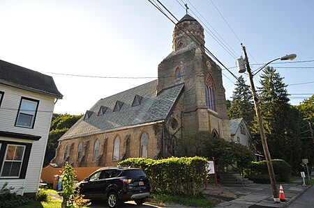
Ponckhockie Union Chapel is a historic chapel at 91 Abruyn Street in Kingston, New York. It was built in 1870, and is a rectangular, Gothic Revival style poured reinforced concrete structure coated in stucco. It is three bays wide and five bays deep, and features a projecting bell tower topped by a truncated spire.It was added to the National Register of Historic Places in 1980.

Excerpt from the Wikipedia article Ponckhockie Union Chapel (License: CC BY-SA 3.0, Authors, Images).

Ponckhockie Union Chapel
Abruyn Street,

Geographical coordinates (GPS) Address Website Nearby Places
placeShow on map

Wikipedia: Ponckhockie Union ChapelContinue reading on Wikipedia

Geographical coordinates (GPS)

Latitude Longitude
N 41.926111111111 ° E -73.974444444444 °
placeShow on map

Address

Ponckhockie Union Congregational Church

Abruyn Street 93
12401
New York, United States
mapOpen on Google Maps

Website
1870historicsite.org

linkVisit website

KingstonNY PonckhockieUnionChapel
Share experience

Nearby Places

Cordts Mansion
Cordts Mansion

Edgewood, aka Cordts Mansion is a historic home located at Kingston in Ulster County, New York. It is an impressive, three story Second Empire style residence built in 1873 for a prominent brick merchant and a manufacturer, John A. Cordts. It features a centered tower, slate sloping concave mansard roof with headed dormer windows, iron roof cresting, a columned front porch verandah, and a bay window.Hutton Brickyards It was listed on the National Register of Historic Places in 2007.Known to the Cordts family as Edgewood, it is an impressive three-story Second Empire mansion, constructed in 1873 for John H. Cordts, a brick merchant, manufacturer and co-founder of the firm of Cordts and Hutton. It is located within the Hudson River Valley National Heritage Area and is prominently sited atop a hill facing east and overlooking the Hudson River. The mansion occupies anine-acre, mostly-landscaped lot located on the east side of Lindsley Avenue, north of Delaware Avenue, in Kingston, New York. Adjoining the mansion lot to the north is Hutton Brickyards; across Lindsley Avenue, to the south and east is Delaware Avenue and residential housing, some of which was owned by the Cordts family and occupied by brick company employees; to the west across Lindsley Avenue, is a wood lot property once owned by the Newark Lime and Cement Manufacturing Company as well as the Moses Yeomans House, a pre-Revolutionary stone house with former ties to the Newark Lime and Cement Manufacturing Company. The Edgewood Mansion is an imposing building with many distinctive exterior details and features associated with the Second Empire style including the centered tower, slate sloping concave mansard roof with hooded dormer windows having jigsaw trim, iron roof cresting much of it topped with finials in a modified fleur de lys style, molded cornices with paired support eave brackets, a columned front porch verandah, round headed windows, and a side bay window facing south on the first and second stories. Windows on the first and second stories and in the arched tower have shutters. The windows are varied but mostly two over two or two over one. The main section of roof beyond the iron cresting and not visible from the grounds is asphalt. The structural system is joisted masonry. The brickwork is painted yellow and appears to be mainly common bond. The architect is not known but the construction would likely have been supervised by John H. Cordts with materials provided by the Cordts and Hutton brickyard and the Hutton Company lumberyard, both nearby. The dimensions are irregular containing numerous projections and setbacks but can be approximated to 45 ft. x 90 ft. on the first story, 45 ft. x 75 ft. on the second story and 36 ft. x 75 ft. on the third story.The mansion is now part of Hutton Brickyards and will available for hotel stays starting in summer of 2022.
Hudson River Maritime Museum

The Hudson River Maritime Museum is a maritime museum dedicated to the Hudson River. It is located at 50 Rondout Landing at the foot of Broadway in Kingston, New York, United States, along Rondout Creek in the city's old waterfront, just east of the John T. Loughran Bridge. The acronym HRMM is often used to refer the Hudson River Maritime Museum in publications. Its collections are devoted to the history of shipping, boating and industry on the Hudson and its tributaries, such as the Rondout, where Kingston grew prosperous early in the 19th century as the northern end of the Delaware and Hudson Canal. The city was the busiest port between New York City and Albany. The museum was founded in 1980 by local Hudson River enthusiasts, but did not move to its present property, an old boat shop, until 1983. Its exhibits include various small craft, artifacts of river steamships such as the Mary Powell, a research library, ice-harvesting tools and maps, paintings and sketches from past eras. The 1898 steam tugboat Mathilda is displayed in the yard next to the museum. In the summer months boat trips are available to nearby Rondout Lighthouse, where the creek drains into the Hudson. Boats putting in at the dock range from privately owned pleasure craft to oceangoing cruise liners. The Hudson River Sloop Clearwater has its winter home port here and visits frequently as do many historic reproduction vessels such as the Onrust and the Half Moon. As well as having the ability to accommodate deep draft vessels at their docks the museum provides free docking for canoes and kayaks. The Hudson River Maritime Museum is home to the Kingston High School Crew Team, the Rondout Rowing Club and the Kingston Sailing Club. The museum is a membership supported organization and sponsors festivals and events including the Antique and Classic Boat Society Boat Show, Hudson River Days with music, crafts and displays, the "Follow the River" Lecture Series, Cinema Sundays and Family Days. HRMM opened the Wooden Boat School in 2016 and the Sailing & Rowing School in 2017. Classes are offered year-round at the Wooden Boat School, and the Sailing & Rowing School limit their offerings to Spring, Summer, and Fall. It is open 11 am - 5 pm, Thursday - Sunday during winter, and 11 am - 5 pm, Monday - Sunday during summer. Admission cost US$9 for adults and US$6 for children and seniors, US$25 family rates available (restrictions apply). Special tours for groups are available. There is a gift shop which features books pertaining to Kingston and the Hudson Valley as well as the maritime history of the Hudson.

Rondout–West Strand Historic District

The Rondout–West Strand Historic District is located on the shore of Rondout Creek along the southern boundary of the city of Kingston, New York, United States. Formerly Rondout, New York, it is bounded by the creek, Broadway, Hone, Ravine and McEntee streets, an area of 570 acres (2.3 km²) containing 259 buildings, most dating to the 19th century. US 9W and the John T. Loughran Bridge are immediately to the east; the Kingston-Port Ewen Suspension Bridge crosses the creek to the west. The neighborhood is often referred to locally by either of the two names. The name of the Rondout Creek comes from the fort, or redoubt, that was erected near its mouth The Dutch equivalent of the English word redoubt (meaning a fort or stronghold), is reduyt. In the Dutch records of Wildwyck, however, the spelling used to designate this same fort is invariably Ronduyt during the earliest period, with the present form rondout (often capitalized) appearing as early as November 22, 1666. Because the spelling of the word was unusual and implied a proper name, the translators, Oppenheim and Versteeg, preserved the original form in their translations instead of giving the English equivalent, as O´Callaghan and Fernow had done. The Dutch word ronduyt is an adjective meaning "frankly" or "positively." The word could also be broken down into its components and translated, literally, "round-out." However, it seems unlikely that the inhabitants of Esopus had any special meaning in mind when they corrupted the Dutch word reduyt into ronduyt and rondout. Most likely, this corrupting process merely represented the simplification of a word (reduyt). The Strand (original pronunciation, in Dutch: "strunt"). Strand means, in Dutch, a shore or beach. The street running along the north shore of the Rondout Creek near its mouth has always been called "The Strand," or, more recently, "Strand Street" (East and West).A short, easily navigable distance up the creek from the Hudson River, the area, originally known as Kingston Landing, had always been an ideal location for a harbor. But it was not until the establishment of the Delaware and Hudson Canal in 1828 made it a key junction for coal being shipped from Northeast Pennsylvania and bluestone being quarried from the nearby Catskill Mountains that it was able to fully take advantage of that situation. Rondout was the eastern terminus of the Rondout and Oswego Railroad (later absorbed into the Ulster and Delaware Railroad), built in the latter 1860s, which took rail cars straight to Rondout Creek. It grew so rapidly that it incorporated as the Village of Rondout in 1849. By 1872 it grew so much more it merged with the then-Town of Kingston to form today's city. By the time the canal closed in 1899, it had acquired buildings in all 19th-century architectural styles.The industrial base established was such that the neighborhood remained prosperous long after the closing of the canal. But by the 1960s it had, like similar areas in many other American cities, fallen into decay, and it was only when urban renewal and the construction of the bridge led to the demolition of part of the neighborhood that efforts to preserve the remainder were seriously undertaken.It was added to the National Register of Historic Places in 1979; the city has recognized it in its ordinances as well. Today, the area is still an active waterfront, although it primarily sees recreational traffic. Many small boutiques and restaurants have opened in the old buildings along the streets; it has become a popular destination for visitors both by land and water. It is located adjacent to the West Strand Historic District, listed on the National Register of Historic Places in 1974.