place

National Rose Garden

1933 establishments in AustraliaCommonwealth Heritage List places in the Australian Capital TerritoryParks established in 1933Parks in CanberraUse Australian English from February 2018
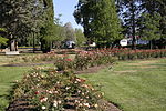
Old parliament house gardens view

The National Rose Gardens are a heritage-listed rose gardens located in Parkes, a suburb of Canberra, in the Australian Capital Territory of Australia. The rose gardens were added to the Australian Commonwealth Heritage List on 22 June 2004.The National Rose Gardens, conceived in 1926 and opened in 1933, were Australia's first national gardening project and were planned as a physical expression of the principle of cooperation between the Commonwealth and the States. In the development of the Gardens roses were contributed by all States in Australia. The Gardens were intended to provide an interest for all Australians in developing Canberra, the national capital, as a garden city. The Gardens demonstrate a distinctive early example of twentieth century public garden design in a formal style. In horticultural terms the Gardens have provided the opportunity to exhibit the best varieties of Australian grown and overseas roses in a favourable climate. Their location in front of the (then Provisional) Old Parliament House was planned to enhance the setting of the House. The Gardens are valued by visitors to Canberra as well as the local community for their aesthetic qualities.

Excerpt from the Wikipedia article National Rose Garden (License: CC BY-SA 3.0, Authors, Images).

National Rose Garden
King George Terrace, Canberra Parkes

Geographical coordinates (GPS) Address Website Nearby Places
placeShow on map

Wikipedia: National Rose GardenContinue reading on Wikipedia

Geographical coordinates (GPS)

Latitude Longitude
N -35.303055555556 ° E 149.13111111111 °
placeShow on map

Address

House of Representatives Garden

King George Terrace
2600 Canberra, Parkes
Australia
mapOpen on Google Maps

Website
nca.gov.au

linkVisit website

Old parliament house gardens view
Share experience

Nearby Places

Old Parliament House, Canberra

Old Parliament House, formerly known as the Provisional Parliament House, was the seat of the Parliament of Australia from 1927 to 1988. The building began operation on 9 May 1927 after Parliament's relocation from Melbourne to the new capital, Canberra. In 1988, the Commonwealth Parliament transferred to the new Parliament House on Capital Hill. It also serves as a venue for temporary exhibitions, lectures and concerts. The Old Parliament is in front of New Parliament Canberra On 2 May 2008 it was made an Executive Agency of the Department of the Prime Minister and Cabinet. On 9 May 2009, the Executive Agency was renamed the Museum of Australian Democracy at Old Parliament House, reporting to the Special Minister of State. Designed by John Smith Murdoch and a team of assistants from the Department of Works and Railways, the building was intended to be neither temporary nor permanent—only to be a "provisional" building that would serve the needs of Parliament for a maximum of 50 years. The design extended from the building itself to include its gardens, décor and furnishings. The building is in the Simplified or "Stripped" Classical Style, commonly used for Australian government buildings constructed in Canberra during the 1920s and 1930s. It does not include such classical architectural elements as columns, entablatures or pediments, but does have the orderliness and symmetry associated with neoclassical architecture.[1]

John Gorton Building

The John Gorton Building, also referred to as the Gorton Building and formerly the Administrative Building, is a heritage listed government office located within the Parliamentary Triangle in Canberra, Australia. The office building is the administrative headquarters of the Department of Climate Change, Energy, the Environment and Water. Planned in 1924, designed in 1946 and completed in 1956, the Administrative Building is significant as a good Canberra example of the Inter-war Stripped Classical style. Key features of this style displayed by the building include: the symmetrical facades; the division of the elevations into vertical bays; the occasional use of correct Classical details; the use of a basic Classical column form; the expressed portico; the simple surface treatments; and subdued spandrels between the storeys which emphasise verticality. Design elements which retain a high level of integrity include the exterior, foyers, lift lobbies and central corridors. The Administrative Building is also part of the significant cultural landscape of the Parliamentary triangle. It occupies a prominent and strategic location flanking the land axis in accordance with the 1916 Griffin plan. Together with the later Treasury Building balancing its mass across the central lawns of the land axis, the Administrative Building contributes to the planned aesthetic qualities of the Parliamentary triangle. The building was listed on the Commonwealth Heritage List on 22 June 2004.

Parliamentary Triangle, Canberra

The National Triangle, which is referred to as the Parliamentary Triangle, is the ceremonial precinct of Canberra, containing some of Australia's most significant buildings. The National Triangle is formed by Commonwealth, Kings and Constitution Avenues. Buildings within the National Triangle have been located and designed intentionally for visual effect, and those of national significance are popular tourist attractions. The National Triangle was a significant feature of Walter Burley Griffin's Plan for Canberra. The apices of the triangle are Parliament House, the seat of government; the Defence Headquarters at Russell; and City Hill, representing the civilian part of Canberra. Griffin planned the city around two axes which converge in the centre of the National Triangle. The land axis connects Mount Ainslie, Capital Hill and Red Hill and extends off towards Mount Bimberi the Australian Capital Territory's highest mountain. The water axis runs at right angles to the land axis along the length of Lake Burley Griffin. The southern shore of Lake Burley Griffin bisects the National Triangle forming a smaller Triangle known as the Parliamentary Zone bounded by Kings and Commonwealth Avenues. Consistent with Walter Burley Griffin's Garden City design, the National Triangle is characterised by streets lined with large deciduous trees, and buildings set in expanses of grassed parkland. Consequently, it has a very open feel and buildings are located several minutes walk away from one another. It was Griffin's original intention for more grand government buildings to be located within the precinct, but these have not eventuated as yet. Development within the National Triangle is strictly controlled by the National Capital Authority, an agency of the Commonwealth Government (not the ACT Government) within the Department of Infrastructure, Transport, Regional Development and Communications.