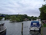
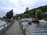
Mill Meadows, Henley-on-Thames
Grasslands of the United KingdomHenley-on-ThamesMeadows in OxfordshireOxfordshire geography stubsParks and open spaces in Oxfordshire ... and 3 more
Parks and open spaces on the River ThamesUse British English from September 2017Water-meadows

Mill Meadows is part of the flood plain of the River Thames at Henley-on-Thames, Oxfordshire, England. It is an area of natural beauty close to the town centre of Henley. Marsh Lock (which is adjacent to the site of the mill that the meadows are named after. The mill race still exists). Rod Eyot and the River and Rowing Museum, established in 1998, are all close by. There is car parking available for visitors.A boat service by Salters Steamers stops at the meadows, travelling to Reading on the river via Shiplake and Sonning. Position: grid reference SU768820
Excerpt from the Wikipedia article Mill Meadows, Henley-on-Thames (License: CC BY-SA 3.0, Authors, Images).Mill Meadows, Henley-on-Thames
Wargrave Road,
Geographical coordinates (GPS) Address Nearby Places Show on map
Geographical coordinates (GPS)
| Latitude | Longitude |
|---|---|
| N 51.53169 ° | E -0.89422 ° |
Address
The Henley Wildlife Group
Wargrave Road
RG9 3HX , Remenham
England, United Kingdom
Open on Google Maps


