place

Long Society Meetinghouse
Churches completed in 1819Churches in New London County, ConnecticutChurches on the National Register of Historic Places in ConnecticutNational Register of Historic Places in New London County, ConnecticutPreston, Connecticut
Long Society Meetinghouse

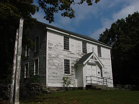
The Long Society Meetinghouse is a historic church building at 45 Long Society Road in Preston, Connecticut. It is one of only about a dozen surviving colonial "broad side" meeting houses, and is the last example surviving in Connecticut that has not been altered from that configuration by the addition of a tower or relocation of its entrance or pulpit. The meeting house was built from 1817 to 1819 on the site of an earlier meetinghouse, incorporating some elements of the earlier building. The meeting house was used both as a church and for civic functions, the reason for its plain, not overtly religious appearance. The building was added to the National Register of Historic Places in 1976.

Excerpt from the Wikipedia article Long Society Meetinghouse (License: CC BY-SA 3.0, Authors, Images).

Long Society Meetinghouse
Long Society Road,

Geographical coordinates (GPS) Address External links Nearby Places
placeShow on map

Wikipedia: Long Society MeetinghouseContinue reading on Wikipedia

Geographical coordinates (GPS)

Latitude Longitude
N 41.534444444444 ° E -72.035833333333 °
placeShow on map

Address

Long Society Meetinghouse

Long Society Road
06380
Connecticut, United States
mapOpen on Google Maps

linkWikiData (Q6673244)
linkOpenStreetMap (1016059031)

Long Society Meetinghouse
Share experience

Nearby Places

Greeneville (Norwich, Connecticut)

Greeneville is a neighborhood of the city of Norwich, Connecticut, located northeast of downtown Norwich along the west bank of the Shetucket River. Most of the neighborhood is designated Greeneville Historic District, a historic district that is listed on the National Register of Historic Places. The district was listed on the National Register in 2005 and includes 683 contributing buildings, seven other contributing structures, and one other contributing site over a 300 acres (120 ha) area.The district is drawn to "correspond to the village as it was laid out in 1833, but also include additional streets laid out and developed in the late nineteenth and early twentieth centuries to accommodate population growth. Areas north and south of the district boundaries were excluded...." as those areas included undeveloped land, or fewer contributing relative to non-contributing buildings, or reflected a "shift in architectural character.": 52 According to the Connecticut Trust for Historic Preservation the district "is a historically significant industrial village that was created to support and sustain water-powered industry from 1828 to about 1940. Much of the enduring success of this industrial enterprise can be attributed to the entrepreneurial vision of industrialist William P. Greene (1795–1862). His development of this planned community and a company to deliver a centralized power system, combined with significant technological infrastructure improvements in the late 19th century, supported the largest industrial presence in Norwich. Although nominally a part of the City of Norwich after 1875, from its creation in 1833 until after World War I Greeneville remained a relatively independent and self-sufficient, working-class community-an evolution fully expressed by the district's large, cohesive collection of generally well-preserved domestic, institutional and commercial architecture. While much of the architecture has the vernacular character expected in a mill town, the district also includes representative examples of the major styles of the period, including Greek Revival, Second Empire, Italianate, and Carpenter Gothic."

Hallville Mill Historic District

Hallville Mill Historic District is a historic district in the town of Preston, Connecticut, that was listed on the National Register of Historic Places in 1996. Contributing properties in the district are 23 buildings, two other contributing structures, and one other contributing site over a 50-acre (20 ha) area. The district includes the dam that forms Hallville Pond (a mill pond), historic manufacturing buildings and worker housing, and the Hallville Mill Bridge, a lenticular pony truss bridge built circa 1890 by the Berlin Iron Bridge Company.Hallville is a historic textile mill village. The first mill on the local stream, Indiantown Brook, was a fulling mill built in 1752 for finishing of locally produced homespun woolen cloth. Carding machines were added in the early 19th century. In 1857 Joseph Hall, Sr., a weaver born in England, built an industrial-scale woolen mill on the site. The mill remained under his family's ownership under the name Hall Brothers' Woolen Mill (named for the founder's sons) and was continually expanded over the years. As of 1888 the mill employed 175 workers and produced 860,000 yards (790,000 m) of cloth annually. The woolen mill burned in 1943, but manufacturing continued in Hallville until the 1960s. It was a major source of employment and tax revenue for the town of Preston.The district has significance "as an intact representative small-scale 19th-century mill village containing a high concentration of contributing buildings and structures built as components of a company-owned town based initially on so-called Rhode Island manufacturing system." As such, the mill and its associated village provide physical evidence of the area's economic transition to industrial production during the late 19th century.: 11 Route 2A, a two-lane undivided highway, passes through Hallville. Increased traffic volumes on this road, attributed to the nearby Foxwoods and Mohegan Sun casinos, are considered to be a threat to the historic character of the village.